
Epirus - Western Macedonia topographic map
Interactive map
Click on the map to display elevation.
About this map
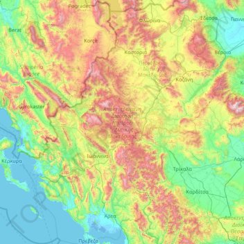
Name: Epirus - Western Macedonia topographic map, elevation, terrain.
Location: Epirus - Western Macedonia, Greece (38.92305 19.97334 40.94346 22.19532)
Average elevation: 661 m
Minimum elevation: -4 m
Maximum elevation: 2,864 m
Other topographic maps
Click on a map to view its topography, its elevation and its terrain.
Σμόλικας
Greece > Epirus - Western Macedonia
Σμόλικας, Konitsa Municipality, Ioannina Regional Unit, Epirus Region, Epirus - Western Macedonia, 44019, Greece
Average elevation: 2,199 m