
Weber County topographic map
Interactive map
Click on the map to display elevation.
About this map
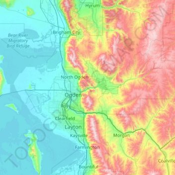
Name: Weber County topographic map, elevation, terrain.
Location: Weber County, Utah, United States (41.07684 -112.49348 41.43393 -111.42038)
Average elevation: 1,722 m
Minimum elevation: 1,278 m
Maximum elevation: 2,919 m
The county extends from high in the Wasatch Range in the east into a portion of the Great Salt Lake to the west, where the county's elongated point exists. The Weber and Ogden rivers and their tributaries run through its valleys. The Weber County Surveyor's office divides the county into two regions, the "Lower Valley" and the "Upper Valley", divided by the ridge of the Wasatch front range south through the county. Lower Valley, adjacent to the Lake, is the county's more populous part. The Upper Valley consists mostly of the Ogden Valley, the watershed of the Ogden River. The county's highest elevation is Willard Peak in the Wasatch Mountains, at 9,763 ft (2,976 m) ASL. The county has an area of 659 square miles (1,710 km2), of which 576 square miles (1,490 km2) is land and 83 square miles (210 km2) (13%) is water. It is the second-smallest county in Utah by land area and third-smallest by total area.
Other topographic maps
Click on a map to view its topography, its elevation and its terrain.
Saint George
United States > Utah > Washington County
Saint George, Washington County, Utah, United States
Average elevation: 929 m
Hatch
United States > Utah > Garfield County
Hatch, Garfield County, Utah, 84735, United States
Average elevation: 2,135 m
Draper Commercial Parkway
United States > Utah > Salt Lake County > Draper
Draper Commercial Parkway, Draper, Salt Lake County, Utah, 84020, United States
Average elevation: 1,355 m
Midlake
United States > Utah > Box Elder County
Midlake, Box Elder County, Utah, United States
Average elevation: 1,282 m
Zion National Park
United States > Utah > Washington County
Zion National Park, Washington County, Utah, United States
Average elevation: 1,877 m
Pinto Lake
United States > Utah > Duchesne County
Pinto Lake, Duchesne County, Utah, United States
Average elevation: 3,106 m
Gates Lake
United States > Utah > Duchesne County
Gates Lake, Duchesne County, Utah, United States
Average elevation: 3,121 m
Stettler
United States > Utah > Weber County > Ogden
Stettler, Ogden, Weber County, Utah, 84404, United States
Average elevation: 1,474 m
Park City
United States > Utah > Summit County
Park City, Summit County, Utah, United States
Average elevation: 2,290 m
Jeremy Ranch
United States > Utah > Summit County
Jeremy Ranch, Summit County, Utah, 84098, United States
Average elevation: 2,048 m
Magna
United States > Utah > Salt Lake County
Magna, Salt Lake County, Utah, United States
Average elevation: 1,341 m
Coal Creek
United States > Utah > Iron County > Cedar City
Coal Creek, Cedar City, Iron County, Utah, United States
Average elevation: 1,922 m
Bellwood Acres
United States > Utah > Salt Lake County > Cottonwood Heights
Bellwood Acres, Cottonwood Heights, Salt Lake County, Utah, 84121, United States
Average elevation: 1,398 m
Fish Lake
United States > Utah > Sevier County
Fish Lake, Sevier County, Utah, United States
Average elevation: 2,886 m
American Fork
United States > Utah > Utah County
American Fork, Utah County, Utah, 84003, United States
Average elevation: 1,405 m
Sprucewood
United States > Utah > Salt Lake County > Sandy
Sprucewood, Sandy, Salt Lake County, Utah, 84094, United States
Average elevation: 1,418 m
West Valley City
United States > Utah > Salt Lake County
West Valley City, Salt Lake County, Utah, United States
Average elevation: 1,351 m
New Harmony
United States > Utah > Washington County
New Harmony, Washington County, Utah, United States
Average elevation: 1,636 m
Wildwood
United States > Utah > Utah County
Wildwood, Utah County, Utah, United States
Average elevation: 1,879 m
Alta
United States > Utah > Salt Lake County
Alta, Salt Lake County, Utah, United States
Average elevation: 2,912 m
Brighton
United States > Utah > Salt Lake County
Brighton, Salt Lake County, Utah, United States
Average elevation: 2,852 m
West Jordan
United States > Utah > Salt Lake County
West Jordan, Salt Lake County, Utah, United States
Average elevation: 1,372 m
Alta Vista
United States > Utah > Weber County > Ogden
Alta Vista, Ogden, Weber County, Utah, United States
Average elevation: 1,505 m
Midvale
United States > Utah > Salt Lake County
Midvale, Salt Lake County, Utah, 84047, United States
Average elevation: 1,331 m
Woods Cross
United States > Utah > Davis County
Woods Cross, Davis County, Utah, 84087, United States
Average elevation: 1,352 m
Midway
United States > Utah > Wasatch County
Midway, Wasatch County, Utah, 84049, United States
Average elevation: 1,751 m
Salt Lake City
United States > Utah > Salt Lake County
Salt Lake City, Salt Lake County, Utah, United States
Average elevation: 1,592 m
Salt Lake City
United States > Utah > Salt Lake County > Salt Lake City
Salt Lake City, Salt Lake County, Utah, 84139, United States
Average elevation: 1,625 m
Three Canyon Rapids
United States > Utah > Carbon County
Three Canyon Rapids, Carbon County, Utah, United States
Average elevation: 1,511 m
Sandy
United States > Utah > Salt Lake County
Sandy, Salt Lake County, Utah, United States
Average elevation: 1,376 m
Moab
United States > Utah > Grand County
Moab, Grand County, Utah, 84532, United States
Average elevation: 1,357 m
Hillborough Heights
United States > Utah > Salt Lake County > Sandy > Hillborough Heights
Hillborough Heights, Sandy, Salt Lake County, Utah, 84093, United States
Average elevation: 1,501 m
South Valence Drainage
United States > Utah > Salt Lake County > West Jordan
South Valence Drainage, West Jordan, Salt Lake County, Utah, United States
Average elevation: 1,388 m
Lake Powell
United States > Utah > Kane County
Lake Powell, Kane County, Utah, United States
Average elevation: 1,555 m
Millcreek
United States > Utah > Salt Lake County > Millcreek
Millcreek, Salt Lake County, Utah, 84106, United States
Average elevation: 1,715 m
Cannonville
United States > Utah > Garfield County > Cannonville
Cannonville, Garfield County, Utah, 84718, United States
Average elevation: 1,894 m
South Jordan
United States > Utah > Salt Lake County > South Jordan
South Jordan, Salt Lake County, Utah, United States
Average elevation: 1,384 m
Riverton
United States > Utah > Riverton > Riverton
Riverton, Salt Lake County, Utah, 84065, United States
Average elevation: 1,376 m
Wildcat Hills
United States > Utah > Box Elder County
Wildcat Hills, Box Elder County, Utah, United States
Average elevation: 1,464 m
Park City
United States > Utah > Summit County > Park City
Park City, Summit County, Utah, 84060, United States
Average elevation: 2,315 m
Peter Sinks
Peter Sinks, Cache County, Utah, United States
Average elevation: 2,555 m
Cedar City
United States > Utah > Iron County
Cedar City, Iron County, Utah, United States
Average elevation: 1,975 m
Provo
United States > Utah > Utah County > Provo
Provo, Utah County, Utah, 84606, United States
Average elevation: 1,733 m
Huntsville
United States > Utah > Huntsville
Huntsville, Weber County, Utah, United States
Average elevation: 1,502 m