
Karnataka topographic map
Interactive map
Click on the map to display elevation.
About this map
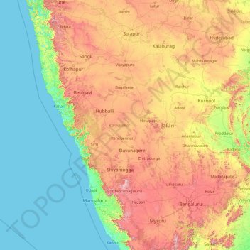
Name: Karnataka topographic map, elevation, terrain.
Location: Karnataka, India (11.59456 74.05439 18.47665 78.58808)
Average elevation: 386 m
Minimum elevation: -1 m
Maximum elevation: 1,771 m
The bulk of the state is in the Bayaluseeme region, the northern part of which is the second-largest arid region in India. The highest point in Karnataka is the Mullayanagiri hills in Chikmagalur district which has an altitude of 1,925 metres (6,316 ft). The two main river systems of the state are the Krishna and its tributaries, the Bhima, Ghataprabha, Vedavathi, Malaprabha and Tungabhadra in North Karnataka, and the Kaveri and its tributaries, the Hemavati, Shimsha, Arkavati, Lakshmana Thirtha and Kabini, in South Karnataka. Most of these rivers flow out of Karnataka eastward, reaching the sea at the Bay of Bengal. Other prominent rivers such as the Sharavati in Shimoga and Netravati in Dakshina Kannada flow westward, reaching the sea at the Arabian Sea. A large number of dams and reservoirs are constructed across these rivers which richly add to the irrigation and hydroelectricity power generation capacities of the state.
Other topographic maps
Click on a map to view its topography, its elevation and its terrain.
Bengaluru
India > Karnataka > Bangalore North
Bengaluru, Bangalore North, Bengaluru Urban District, Karnataka, India
Average elevation: 881 m
Chennai
India > Tamil Nadu > Chennai
Chennai, Chennai District, Tamil Nadu, India
Average elevation: 8 m
3d
India > Rajasthan > Ganganagar Tehsil > 1 LNP
3d, 1 LNP, Ganganagar Tehsil, Sri Ganganagar District, Rajasthan, India
Average elevation: 178 m
Tamnath
India > Maharashtra > Karjat
Tamnath, Karjat, Raigad, Maharashtra, 410201, India
Average elevation: 110 m
Shimla
India > Himachal Pradesh > Shimla (urban)
Shimla, Shimla (urban), Shimla District, Himachal Pradesh, 171001, India
Average elevation: 1,557 m
Bhubaneshwar
India > Odisha > Bhubaneswar (M.Corp.)
Bhubaneshwar, Bhubaneswar Municipal Corporation, Bhubaneswar (M.Corp.), Khordha District, Odisha, 751001, India
Average elevation: 30 m
Patna
India > Bihar > Patna Rural
Patna, Patna Rural, Patna District, Bihar, 800001, India
Average elevation: 51 m
Srinagar
India > Jammu and Kashmir > Srinagar (South)
Srinagar, Srinagar (South), Srinagar District, Jammu and Kashmir, 190001, India
Average elevation: 1,805 m
Kolkata
Kolkata, Kolkata District, West Bengal, 700073, India
Average elevation: 5 m
Jaipur
India > Rajasthan > Jaipur Tehsil
Jaipur, Jaipur Municipal Corporation, Jaipur Tehsil, Jaipur District, Rajasthan, 302001, India
Average elevation: 408 m
Kadaganchi
India > Karnataka > Alanda taluku
Kadaganchi, Alanda taluku, Kalaburagi District, Karnataka, 585311, India
Average elevation: 528 m
Jodhpur
India > Rajasthan > Jodhpur Tehsil
Jodhpur, Jodhpur Tehsil, Jodhpur District, Rajasthan, India
Average elevation: 238 m
Indore
India > Madhya Pradesh > Juni Indore Tahsil
Indore, Juni Indore Tahsil, Indore District, Madhya Pradesh, 452001, India
Average elevation: 555 m
Nuapatana
India > Odisha > Narasinghpur
Nuapatana, Narasinghpur, Cuttack District, Odisha, 754032, India
Average elevation: 63 m
Bhubaneswar Municipal Corporation
India > Odisha > Bhubaneswar (M.Corp.)
Bhubaneswar Municipal Corporation, Bhubaneswar (M.Corp.), Khordha, Odisha, India
Average elevation: 37 m
Kanakapura
India > Karnataka > Kanakapura taluk
Kanakapura, Kanakapura taluk, Ramanagara District, Karnataka, 562117, India
Average elevation: 663 m
Hosur
India > Tamil Nadu > Hosur
Hosur, Krishnagiri District, Tamil Nadu, 635109, India
Average elevation: 859 m
Tharangambadi
Tharangambadi, Mayiladuthurai District, Tamil Nadu, India
Average elevation: 5 m
Gudibande
India > Karnataka > Gudibande taluk
Gudibande, Gudibande taluk, Chikkaballapura District, Karnataka, 561209, India
Average elevation: 833 m
Gurgaon
India > Haryana > Gurugram District
Gurgaon, Gurugram District, Haryana, India
Average elevation: 237 m
Kaas Valley of Flowers
India > Maharashtra > Jaoli > Daund
Kaas Valley of Flowers, Daund, Jaoli, Satara, Maharashtra, India
Average elevation: 1,011 m
Chhindwara
India > Madhya Pradesh > Chhindwara Tahsil
Chhindwara, Chhindwara Tahsil, Chhindwara District, Madhya Pradesh, 480001, India
Average elevation: 683 m
Thirukodikaval
India > Tamil Nadu > Thiruvidaimarudur
Thirukodikaval, Thiruvidaimarudur, Thanjavur District, Tamil Nadu, 609803, India
Average elevation: 18 m