
United Kingdom topographic map
Interactive map
Click on the map to display elevation.
About this map
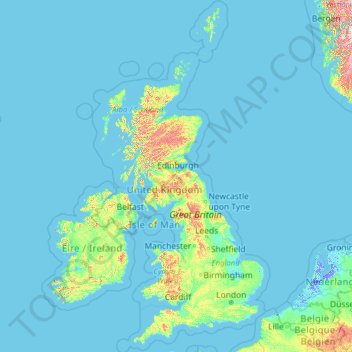
Name: United Kingdom topographic map, elevation, terrain.
Location: United Kingdom (49.67400 -14.01552 61.06100 2.09191)
Average elevation: 42 m
Minimum elevation: -6 m
Maximum elevation: 1,617 m
Scotland accounts for just under one-third (32 per cent) of the total area of the UK, covering 78,772 square kilometres (30,410 sq mi). This includes nearly 800 islands, predominantly west and north of the mainland; notably the Hebrides, Orkney Islands and Shetland Islands. Scotland is the most mountainous country in the UK and its topography is distinguished by the Highland Boundary Fault – a geological rock fracture – which traverses Scotland from Arran in the west to Stonehaven in the east. The fault separates two distinctively different regions; namely the Highlands to the north and west and the Lowlands to the south and east. The more rugged Highland region contains the majority of Scotland's mountainous land, including Ben Nevis which at 1,345 metres (4,413 ft) is the highest point in the British Isles. Lowland areas – especially the narrow waist of land between the Firth of Clyde and the Firth of Forth known as the Central Belt – are flatter and home to most of the population including Glasgow, Scotland's largest city, and Edinburgh, its capital and political centre, although upland and mountainous terrain lies within the Southern Uplands.
Other topographic maps
Click on a map to view its topography, its elevation and its terrain.
Canada
Canada
Average elevation: 254 m
Vancouver
Canada > British Columbia > Metro Vancouver Regional District
Vancouver, Metro Vancouver Regional District, British Columbia, Canada
Average elevation: 34 m
Montreal
Canada > Quebec > Urban agglomeration of Montreal
Montreal, Urban agglomeration of Montreal, Montreal (administrative region), Quebec, Canada
Average elevation: 29 m
Vancouver Island
Vancouver Island, British Columbia, Canada
Average elevation: 411 m
Sioux Falls
United States > South Dakota > Minnehaha County
Sioux Falls, Sioux Falls Township, Minnehaha County, South Dakota, United States
Average elevation: 445 m
Manitoulin Island
Canada > Ontario > Manitoulin District
Manitoulin Island, Manitoulin District, Northeastern Ontario, Ontario, Canada
Average elevation: 194 m
Fort McMurray
Canada > Alberta > Division No. 16
Fort McMurray, Division No. 16, Alberta, Canada
Average elevation: 345 m
Yellowstone National Park
Yellowstone National Park, Wyoming, United States
Average elevation: 2,450 m
Magog
Canada > Quebec > Memphrémagog
Magog, Memphrémagog, Estrie, Quebec, Canada
Average elevation: 250 m
Halifax
Canada > Nova Scotia > Halifax County
Halifax, Halifax Regional Municipality, Halifax County, Nova Scotia, Canada
Average elevation: 46 m
Edmonton
Canada > Alberta > Division No. 11
Edmonton, Division No. 11, Alberta, Canada
Average elevation: 690 m
USA
United States > Texas > Tarrant County > Arlington
USA, Arlington, Tarrant County, Texas, 76011, United States
Average elevation: 170 m
Hernando County
Hernando County, Florida, United States
Average elevation: 18 m
Santa Monica
Santa Monica, California, United States
Average elevation: 30 m
Abbotsford
Canada > British Columbia > Fraser Valley Regional District
Abbotsford, Fraser Valley Regional District, British Columbia, Canada
Average elevation: 99 m
Cochrane
Canada > Alberta > Town of Cochrane > Cochrane
Cochrane, Town of Cochrane, Alberta, T4V 2A7, Canada
Average elevation: 1,205 m
Lubbock
United States > Texas > Lubbock County
Lubbock, Lubbock County, Texas, United States
Average elevation: 983 m
Europe
Europe
Average elevation: 223 m
Kamloops
Canada > British Columbia > Thompson-Nicola Regional District
Kamloops, Thompson-Nicola Regional District, British Columbia, Canada
Average elevation: 833 m
Białystok
Poland > Podlaskie Voivodeship
Białystok, Podlaskie Voivodeship, Poland
Average elevation: 140 m
Hungary
Hungary
Average elevation: 259 m
Vaughan
Canada > Ontario > York Region
Vaughan, York Region, Golden Horseshoe, Ontario, Canada
Average elevation: 220 m
Victoria
Canada > British Columbia > Capital Regional District
Victoria, Capital Regional District, British Columbia, Canada
Average elevation: 17 m
Metro Vancouver Regional District
Metro Vancouver Regional District, British Columbia, Canada
Average elevation: 343 m
Regina
Canada > Saskatchewan > Division No. 6
Regina, Division No. 6, Saskatchewan, Canada
Average elevation: 582 m
Nanaimo
Canada > British Columbia > Regional District of Nanaimo
Nanaimo, Regional District of Nanaimo, British Columbia, Canada
Average elevation: 110 m