
Virginia topographic map
Interactive map
Click on the map to display elevation.
About this map
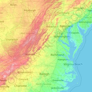
Name: Virginia topographic map, elevation, terrain.
Location: Virginia, United States (36.54079 -83.67537 39.46601 -75.16644)
Average elevation: 248 m
Minimum elevation: -3 m
Maximum elevation: 1,906 m
Forests cover 62% of Virginia as of 2019, of which 78% is considered hardwood forest, meaning that trees in Virginia are primarily deciduous and broad-leaved. The other 22% is pine, with Loblolly and shortleaf pine dominating much of central and eastern Virginia. In the western and mountainous parts of the Commonwealth, oak and hickory are most common, while lower altitudes are more likely to have small but dense stands of moisture-loving hemlocks and mosses in abundance. Spongy moth infestations in oak trees and the blight in chestnut trees have decreased both of their numbers, leaving more room for hickory and invasive ailanthus trees. In the lowland tidewater and Piedmont, yellow pines tend to dominate, with bald cypress wetland forests in the Great Dismal and Nottoway swamps. Other common trees include red spruce, Atlantic White cedar, tulip-poplar, and the flowering dogwood, the state tree and flower, as well as willows, ashes, and laurels. Plants like milkweed, dandelions, daisies, ferns, and Virginia creeper, which is featured on the state flag, are also common. The Thompson Wildlife Area in Fauquier is known for one of the largest populations of trillium wildflowers in all of North America.
Other topographic maps
Click on a map to view its topography, its elevation and its terrain.
Colorado Springs
United States > Colorado > El Paso County
Colorado Springs, El Paso County, Colorado, United States
Average elevation: 2,252 m
USA
United States > Texas > Tarrant County > Arlington
USA, Arlington, Tarrant County, Texas, 76011, United States
Average elevation: 170 m
Baton Rouge
United States > Louisiana > East Baton Rouge Parish
Baton Rouge, East Baton Rouge Parish, Louisiana, United States
Average elevation: 13 m
Galveston
United States > Texas > Galveston County
Galveston, Galveston County, Texas, United States
Average elevation: 1 m
Phoenix
United States > Arizona > Maricopa County
Phoenix, Maricopa County, Arizona, United States
Average elevation: 481 m
Merritt Island
United States > Florida > Brevard County > Cocoa
Merritt Island, Cocoa, Brevard County, Florida, United States
Average elevation: 4 m
Gaylord
United States > Michigan > Otsego County > Gaylord
Gaylord, Otsego County, Michigan, United States
Average elevation: 401 m
Overland Park
United States > Kansas > Johnson County
Overland Park, Johnson County, Kansas, United States
Average elevation: 300 m
Lubbock
United States > Texas > Lubbock County
Lubbock, Lubbock County, Texas, United States
Average elevation: 983 m
Crystal River
United States > Florida > Citrus County
Crystal River, Citrus County, Florida, 34429, United States
Average elevation: 4 m
Hernando County
Hernando County, Florida, United States
Average elevation: 18 m
Seminole County
Seminole County, Florida, United States
Average elevation: 14 m
Yellowstone National Park
Yellowstone National Park, Wyoming, United States
Average elevation: 2,450 m
Huntington Beach
United States > California > Orange County
Huntington Beach, Orange County, California, United States
Average elevation: 7 m
Sioux Falls
United States > South Dakota > Minnehaha County
Sioux Falls, Sioux Falls Township, Minnehaha County, South Dakota, United States
Average elevation: 445 m
Bellevue
United States > Washington > King County
Bellevue, King County, Washington, United States
Average elevation: 66 m
Seattle
United States > Washington > King County
Seattle, King County, Washington, United States
Average elevation: 40 m
San Francisco
San Francisco, California, United States
Average elevation: 63 m
West Tennessee
West Tennessee, Tennessee, United States
Average elevation: 127 m
Chico
United States > California > Butte County
Chico, Butte County, California, United States
Average elevation: 94 m
Beaver County
Beaver County, Pennsylvania, United States
Average elevation: 325 m
Saint Mary's County
Saint Mary's County, Maryland, United States
Average elevation: 13 m
Ontario
United States > Oregon > Malheur County > Ontario
Ontario, Malheur County, Oregon, 97914, United States
Average elevation: 660 m
Leander
United States > Texas > Williamson County > Leander
Leander, Williamson County, Texas, 78641, United States
Average elevation: 297 m
Bozeman
United States > Montana > Gallatin County
Bozeman, Gallatin County, Montana, United States
Average elevation: 1,495 m
Bismarck
United States > North Dakota > Burleigh County
Bismarck, Burleigh County, North Dakota, United States
Average elevation: 523 m
Laguna Beach
United States > California > Orange County
Laguna Beach, Orange County, California, United States
Average elevation: 62 m
San Rafael
United States > California > Marin County
San Rafael, Marin County, California, United States
Average elevation: 78 m
Oklahoma County
Oklahoma County, Oklahoma, United States
Average elevation: 354 m
Worcester County
Worcester County, Massachusetts, United States
Average elevation: 192 m
Golden
United States > Colorado > Jefferson County
Golden, Jefferson County, Colorado, United States
Average elevation: 1,936 m
Bucks County
Bucks County, Pennsylvania, United States
Average elevation: 98 m
Grand Rapids
United States > Michigan > Kent County
Grand Rapids, Kent County, Michigan, United States
Average elevation: 216 m
Salisbury Meadow
United States > New York > Rockland County > Town of Stony Point
Salisbury Meadow, Town of Stony Point, Rockland County, New York, United States
Average elevation: 97 m
Westchester County
Westchester County, New York, United States
Average elevation: 95 m
Rockland County
Rockland County, New York, United States
Average elevation: 138 m
Rapid City
United States > South Dakota > Pennington County
Rapid City, Pennington County, South Dakota, United States
Average elevation: 1,067 m
Redding
United States > California > Shasta County
Redding, Shasta County, CAL Fire Northern Region, California, United States
Average elevation: 240 m
Manhattan
United States > Kansas > Riley County
Manhattan, Riley County, Kansas, United States
Average elevation: 344 m
Saint George
United States > Utah > Washington County
Saint George, Washington County, Utah, United States
Average elevation: 929 m