
Kunming topographic map
Interactive map
Click on the map to display elevation.
About this map
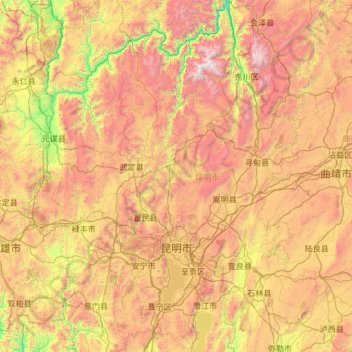
Name: Kunming topographic map, elevation, terrain.
Location: Kunming, Yunnan, China (24.38885 102.16974 26.54849 103.66835)
Average elevation: 2,005 m
Minimum elevation: 714 m
Maximum elevation: 4,151 m
Kunming (/kʊnˈmɪŋ/; Chinese: 昆明; pinyin: Kūnmíng), also known as Yunnan-Fu, is the capital and largest city of Yunnan province, China. It is the political, economic, communications and cultural centre of the province as well as the seat of the provincial government. The headquarters of many of Yunnan's large businesses are in Kunming. It was important during World War II as a Chinese military center, American air base, and transport terminus for the Burma Road. In the middle of the Yunnan–Guizhou Plateau, Kunming is at an altitude of 1,900 metres (6,234 feet) above sea level and a latitude just north of the Tropic of Cancer. As of 2020 census, Kunming had a total population of 8,460,088 inhabitants, of whom 5,604,310 lived in its built-up (or metro) area made of all urban districts but Jinning, not conurbated yet. It is at the northern edge of Dian Lake, surrounded by temples and lake-and-limestone hill landscapes.
Other topographic maps
Click on a map to view its topography, its elevation and its terrain.
Wuhua District
Wuhua District, Kunming, Yunnan, China
Average elevation: 2,104 m
Di'an
China > Yunnan > Luoping County
Di'an, Luoping County, Qujing City, Yunnan, China
Average elevation: 1,489 m
Qihe
China > Yunnan > Gucheng District
Qihe, Gucheng District, Lijiang City, Yunnan, China
Average elevation: 2,529 m
Hanzhuang
China > Yunnan > Longyang District
Hanzhuang, Longyang District, Baoshan, Yunnan, China
Average elevation: 1,987 m
Nanda
China > Yunnan > Shilin Yi Autonomous County > Dake
Nanda, Dake, Shilin Yi Autonomous County, Yunnan, China
Average elevation: 1,851 m
Jinchen Subdistrict
China > Yunnan > Kunming > Jinchen Subdistrict
Jinchen Subdistrict, Panlong District, Kunming, Yunnan, China
Average elevation: 1,918 m
Panlong District
Panlong District, Kunming, Yunnan, China
Average elevation: 2,138 m
Jinghong City
China > Yunnan > Jinghong City
Jinghong City, Xishuangbanna Dai Autonomous Prefecture, Yunnan, 666100, China
Average elevation: 1,120 m
Guangnan
China > Yunnan > Guangnan County > Guangnan
Guangnan, Guangnan County, Wenshan Zhuang and Miao Autonomous Prefecture, Yunnan, China
Average elevation: 1,317 m
Diqing
China > Yunnan > Dêqên Tibetan Autonomous Prefecture > Jiantang
Diqing, Jiantang, Shangri-La County, Dêqên Tibetan Autonomous Prefecture, Yunnan, 674400, China
Average elevation: 3,328 m