
Lucknow topographic map
Interactive map
Click on the map to display elevation.
About this map
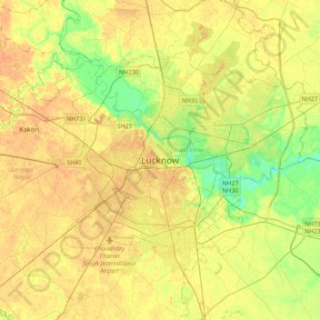
Name: Lucknow topographic map, elevation, terrain.
Location: Lucknow, Lucknow District, Uttar Pradesh, 226027, India (26.67810 80.77460 26.99810 81.09460)
Average elevation: 120 m
Minimum elevation: 103 m
Maximum elevation: 131 m
Lucknow stands at an elevation of approximately 123 metres (404 ft) above sea level. The city had an area of 402 km2 (155 square miles) until December 2019, when 88 villages were added to the municipal limits and the area increased to 631 km2 (244 square miles). Bounded on the east by Barabanki, on the west by Unnao, on the south by Raebareli and in the north by Sitapur and Hardoi, Lucknow sits on the northwestern shore of the Gomti River. As of 2008, there were 110 wards in the city. Morphologically, three clear demarcations exist: The Central business district, which is a fully built up area, comprises Hazratganj, Aminabad and Chowk. A middle zone surrounds the inner zone with cement houses while the outer zone consists of slums.
Other topographic maps
Click on a map to view its topography, its elevation and its terrain.
Vikram Nagar
India > Uttar Pradesh > Lucknow
Vikram Nagar, Lucknow, Lucknow District, Uttar Pradesh, 226008, India
Average elevation: 124 m
Tiwariganj
India > Uttar Pradesh > Lucknow
Tiwariganj, Lucknow, Lucknow District, Uttar Pradesh, 226028, India
Average elevation: 117 m
बड़ा भरवांरा
India > Uttar Pradesh > Lucknow
बड़ा भरवांरा, Lucknow, Uttar Pradesh, 227105, India
Average elevation: 115 m
Gwari
India > Uttar Pradesh > Lucknow
Gwari, Lucknow, Lucknow District, Uttar Pradesh, 226010, India
Average elevation: 113 m