
Uruguay topographic map
Interactive map
Click on the map to display elevation.
About this map
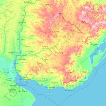
Name: Uruguay topographic map, elevation, terrain.
Location: Uruguay (-35.78245 -58.49477 -30.08540 -53.07558)
Average elevation: 83 m
Minimum elevation: -4 m
Maximum elevation: 485 m
Located entirely within the southern temperate zone, Uruguay has a climate that is relatively mild and fairly uniform nationwide. According to the Köppen Climate Classification, most of the country has a humid subtropical climate (Cfa). Only in some spots of the Atlantic Coast and at the summit of the highest hills of the Cuchilla Grande the climate is oceanic (Cfb). The country experiences the four seasons, with summer being from December to March and winter from June to September. Seasonal variations are pronounced, but extremes in temperature are rare. Summers are tempered by winds off the Atlantic, and severe cold in winter is unknown. Although it never gets too cold, frosts occur every year during the winter months, and precipitation such as sleet and graupel occur almost every winter, but snow is very rare; it does occur every couple of years at higher elevations, but almost always without accumulation. As would be expected with its abundance of water, high humidity and fog are common. The absence of mountains, which act as weather barriers, makes all locations vulnerable to high winds and rapid changes in weather as fronts or storms sweep across the country. These storms can be strong; they can bring squalls, hail, and sometimes even tornadoes. The country experiences extratropical cyclones but no tropical cyclones, due to the fact that the South Atlantic Ocean is rarely warm enough for their development. Both summer and winter weather may vary from day to day with the passing of storm fronts, where a hot northerly wind may occasionally be followed by a cold wind (pampero) from the Argentine Pampas.
Other topographic maps
Click on a map to view its topography, its elevation and its terrain.
Vancouver
Canada > British Columbia > Metro Vancouver Regional District
Vancouver, Metro Vancouver Regional District, British Columbia, Canada
Average elevation: 34 m
Edmonton
Canada > Alberta > Division No. 11
Edmonton, Division No. 11, Alberta, Canada
Average elevation: 690 m
Canada
Canada
Average elevation: 254 m
Winnipeg
Canada > Manitoba > Division No. 11
Winnipeg, Division No. 11, Manitoba, Canada
Average elevation: 236 m
Montreal
Canada > Quebec > Urban agglomeration of Montreal
Montreal, Urban agglomeration of Montreal, Montreal (administrative region), Quebec, Canada
Average elevation: 29 m
Colorado Springs
United States > Colorado > El Paso County
Colorado Springs, El Paso County, Colorado, United States
Average elevation: 2,252 m
Quebec
Canada > Quebec > Urban agglomeration of Québec
Quebec, Urban agglomeration of Québec, Capitale-Nationale, Quebec, Canada
Average elevation: 117 m
Niagara Falls
Canada > Ontario > Niagara Region
Niagara Falls, Niagara Region, Golden Horseshoe, Ontario, Canada
Average elevation: 179 m
Galveston
United States > Texas > Galveston County
Galveston, Galveston County, Texas, United States
Average elevation: 1 m
Surrey
Canada > British Columbia > Metro Vancouver Regional District
Surrey, Metro Vancouver Regional District, British Columbia, Canada
Average elevation: 28 m
Oakville
Canada > Ontario > Halton Region
Oakville, Halton Region, Golden Horseshoe, Ontario, Canada
Average elevation: 104 m
Old Toronto
Old Toronto, Toronto, Golden Horseshoe, Ontario, Canada
Average elevation: 116 m
Kelowna
Canada > British Columbia > Regional District of Central Okanagan
Kelowna, Regional District of Central Okanagan, British Columbia, Canada
Average elevation: 704 m
Bragg Creek
Bragg Creek, Census Divsion No. 6, Alberta, T0L 0K0, Canada
Average elevation: 1,384 m
Victoria
Canada > British Columbia > Capital Regional District
Victoria, Capital Regional District, British Columbia, Canada
Average elevation: 17 m
Kitchener
Canada > Ontario > Region of Waterloo
Kitchener, Region of Waterloo, Southwestern Ontario, Ontario, Canada
Average elevation: 336 m
Saskatoon
Canada > Saskatchewan > Division No. 11
Saskatoon, Division No. 11, Saskatchewan, Canada
Average elevation: 504 m
Vernon
Canada > British Columbia > Regional District of North Okanagan
Vernon, Regional District of North Okanagan, British Columbia, Canada
Average elevation: 676 m
USA
United States > Texas > Tarrant County > Arlington
USA, Arlington, Tarrant County, Texas, 76011, United States
Average elevation: 170 m
Baton Rouge
United States > Louisiana > East Baton Rouge Parish
Baton Rouge, East Baton Rouge Parish, Louisiana, United States
Average elevation: 13 m
Nanaimo
Canada > British Columbia > Regional District of Nanaimo
Nanaimo, Regional District of Nanaimo, British Columbia, Canada
Average elevation: 110 m
West Vancouver
Canada > British Columbia > Metro Vancouver Regional District
West Vancouver, Metro Vancouver Regional District, British Columbia, Canada
Average elevation: 384 m
Kamloops
Canada > British Columbia > Thompson-Nicola Regional District
Kamloops, Thompson-Nicola Regional District, British Columbia, Canada
Average elevation: 833 m
Abbotsford
Canada > British Columbia > Fraser Valley Regional District
Abbotsford, Fraser Valley Regional District, British Columbia, Canada
Average elevation: 99 m
Nose Hill Park
Nose Hill Park, Calgary, Alberta, T3K 2P6, Canada
Average elevation: 1,174 m
North Vancouver
Canada > British Columbia > North Vancouver
North Vancouver, Metro Vancouver Regional District, British Columbia, V7M 1H9, Canada
Average elevation: 258 m
Phoenix
United States > Arizona > Maricopa County
Phoenix, Maricopa County, Arizona, United States
Average elevation: 481 m