
Madrid topographic map
Interactive map
Click on the map to display elevation.
About this map
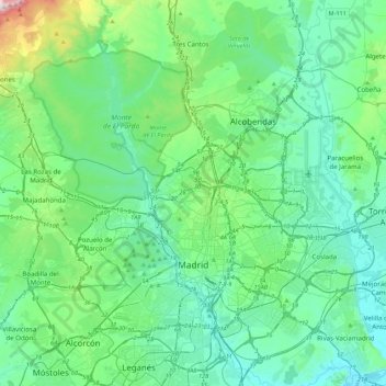
Name: Madrid topographic map, elevation, terrain.
Location: Madrid, Community of Madrid, Spain (40.31198 -3.88895 40.64373 -3.51792)
Average elevation: 671 m
Minimum elevation: 524 m
Maximum elevation: 1,389 m
Madrid lies in the centre of the Iberian peninsula on the southern Meseta Central, 60 km south of the Guadarrama mountain range and straddling the Jarama and Manzanares river sub-drainage basins, in the wider Tagus River catchment area. With an average altitude of 650 metres (2,130 ft), Madrid is the second highest capital of Europe (after Andorra la Vella). There is a considerable difference in altitude within the city proper ranging from the 700 m (2,297 ft) around Plaza de Castilla in the north of city to the 570 m (1,870 ft) around La China wastewater treatment plant on the Manzanares' riverbanks, near the latter's confluence with the Fuente Castellana thalweg in the south of the city. The Monte de El Pardo (a protected forested area covering over a quarter of the municipality) reaches its top altitude (843 m (2,766 ft)) on its perimeter, in the slopes surrounding El Pardo reservoir [es] located at the north-western end of the municipality, in the Fuencarral-El Pardo district.
Other topographic maps
Click on a map to view its topography, its elevation and its terrain.
Paracuellos de Jarama
Paracuellos de Jarama, Community of Madrid, 28860, Spain
Average elevation: 640 m
Tres Cantos
Spain > Community of Madrid > Área metropolitana de Madrid y Corredor del Henares
Tres Cantos, Área metropolitana de Madrid y Corredor del Henares, Community of Madrid, 28760, Spain
Average elevation: 720 m
Madrid
Spain > Community of Madrid > Área metropolitana de Madrid y Corredor del Henares > Madrid
Madrid, Área metropolitana de Madrid y Corredor del Henares, Community of Madrid, 28080, Spain
Average elevation: 650 m
Torrejón de Ardoz
Spain > Community of Madrid > Área metropolitana de Madrid y Corredor del Henares > Torrejón de Ardoz
Torrejón de Ardoz, Área metropolitana de Madrid y Corredor del Henares, Community of Madrid, Spain
Average elevation: 604 m
Pinilla del Valle
Spain > Community of Madrid > Pinilla del Valle
Pinilla del Valle, Sierra Norte, Community of Madrid, Spain
Average elevation: 1,348 m
Alcalá de Henares
Spain > Community of Madrid > Alcalá de Henares
Alcalá de Henares, Área metropolitana de Madrid y Corredor del Henares, Community of Madrid, Spain
Average elevation: 642 m
Cercedilla
Spain > Community of Madrid > Cercedilla
Cercedilla, Cuenca del Guadarrama, Community of Madrid, Spain
Average elevation: 1,469 m
Castellana
Spain > Community of Madrid > Madrid
Castellana, Salamanca, Madrid, Área metropolitana de Madrid y Corredor del Henares, Community of Madrid, 28001, Spain
Average elevation: 691 m
Brunete
Spain > Community of Madrid > Brunete
Brunete, Cuenca del Guadarrama, Community of Madrid, 28690, Spain
Average elevation: 629 m
Villanueva de la Cañada
Spain > Community of Madrid > Cuenca del Guadarrama > Villanueva de la Cañada
Villanueva de la Cañada, Cuenca del Guadarrama, Community of Madrid, 28691, Spain
Average elevation: 641 m
Hortaleza
Spain > Community of Madrid > Madrid
Hortaleza, Madrid, Área metropolitana de Madrid y Corredor del Henares, Community of Madrid, 28001, Spain
Average elevation: 687 m