
Jammu and Kashmir topographic map
Interactive map
Click on the map to display elevation.
About this map
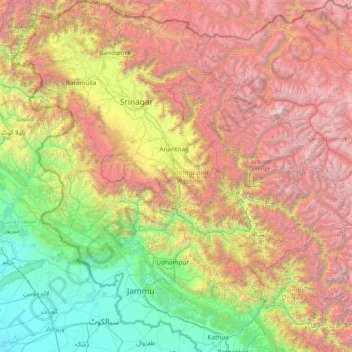
Name: Jammu and Kashmir topographic map, elevation, terrain.
Location: Jammu and Kashmir, India (32.27636 73.75003 34.78714 76.78032)
Average elevation: 2,430 m
Minimum elevation: 208 m
Maximum elevation: 7,015 m
Jammu and Kashmir is home to several valleys such as the Kashmir Valley, Tawi Valley, Chenab Valley, Poonch Valley, Sind Valley and Lidder Valley. The Kashmir valley is 100 km (62 mi) wide and 15,520.3 km2 (5,992.4 sq mi) in area. The Himalayas divide the Kashmir valley from the Tibetan plateau while the Pir Panjal range, which encloses the valley from the west and the south, separates it from the Punjab Plain of the Indo-Gangetic Plain. Along the northeastern flank of the Valley runs the main range of the Himalayas. This valley has an average height of 1,850 metres (6,070 ft) above sea-level, but the surrounding Pir Panjal range has an average elevation of 10,000 feet (3,000 m). The Jhelum River is the major Himalayan river which flows through the Kashmir valley. The Tawi, Ravi and Chenab are the other important rivers flowing through the region.
Other topographic maps
Click on a map to view its topography, its elevation and its terrain.
Visakhapatnam
India > Andhra Pradesh > Visakhapatnam (Urban)
Visakhapatnam, Visakhapatnam (Urban), Visakhapatnam, Andhra Pradesh, 530001, India
Average elevation: 41 m
Lucknow
India > Uttar Pradesh > Lucknow
Lucknow, Lucknow District, Uttar Pradesh, 226027, India
Average elevation: 120 m
Tirupati
India > Andhra Pradesh > Tirupati (Urban)
Tirupati, Tirupati (Urban), Tirupati, Andhra Pradesh, 517500, India
Average elevation: 319 m
Vadodara Rural Taluka
Vadodara Rural Taluka, Vadodara District, Gujarat, India
Average elevation: 35 m
Nava Raipur
India > Chhattisgarh > Arang Tahsil
Nava Raipur, Arang Tahsil, Raipur District, Chhattisgarh, India
Average elevation: 305 m
Deoli
India > Rajasthan > Deoli Tehsil
Deoli, Deoli Tehsil, Tonk District, Rajasthan, 323802, India
Average elevation: 332 m
Baba Bakala Tahsil
Baba Bakala Tahsil, Amritsar District, Punjab, India
Average elevation: 239 m
Navi Mumbai
India > Maharashtra > Navi Mumbai
Navi Mumbai, Thane, Maharashtra, 400706, India
Average elevation: 30 m
Ponneri
India > Tamil Nadu > Ponneri
Ponneri, Thiruvallur District, Tamil Nadu, 601204, India
Average elevation: 10 m
Seelam Pur Tehsil
Seelam Pur Tehsil, North East Delhi District, Delhi, India
Average elevation: 208 m
Gandhinagar
India > Gujarat > Gandhinagar Taluka
Gandhinagar, Gandhinagar Taluka, Gandhinagar District, Gujarat, India
Average elevation: 75 m
Zemu Glacier
India > Sikkim > Chungthang
Zemu Glacier, Chungthang, Mangan District, Sikkim, India
Average elevation: 5,510 m
Rajkot
India > Gujarat > Rajkot Taluka
Rajkot, Rajkot Taluka, Rajkot District, Gujarat, 360001, India
Average elevation: 141 m
Chikhli
India > Gujarat > Chikhli Taluka
Chikhli, Chikhli Taluka, Navsari District, Gujarat, 396521, India
Average elevation: 23 m
Kaniyambādi
India > Tamil Nadu > Vellore
Kaniyambādi, Vellore, Vellore District, Tamil Nadu, 632102, India
Average elevation: 253 m
Dudhsagar Falls
India > Goa > Dharbandora
Dudhsagar Falls, Dharbandora, South Goa District, Goa, India
Average elevation: 418 m
Sahaspur
India > Uttar Pradesh > Dhampur
Sahaspur, Dhampur, Bijnor District, Uttar Pradesh, 246745, India
Average elevation: 217 m
Lake Vasuki Tal
India > Uttarakhand > Ukhimath > Kedarnath
Lake Vasuki Tal, Kedarnath, Ukhimath, Rudraprayag District, Uttarakhand, India
Average elevation: 4,303 m
Tiruchirappalli
India > Tamil Nadu > Tiruchirappalli
Tiruchirappalli, Tiruchchirappalli district, Tamil Nadu, 620001, India
Average elevation: 83 m
Ghatlodiya Taluka
Ghatlodiya Taluka, Ahmedabad District, Gujarat, India
Average elevation: 53 m
Collem
India > Goa > Dharbandora
Collem, Dharbandora, South Goa District, Goa, India
Average elevation: 90 m
Kanchipuram
India > Tamil Nadu > Kanchipuram
Kanchipuram, Kancheepuram, Kanchipuram District, Tamil Nadu, 631501, India
Average elevation: 82 m
Rajpura
India > Rajasthan > Shahpura Tehsil
Rajpura, Shahpura Tehsil, Jaipur(Rural) District, Rajasthan, 303103, India
Average elevation: 451 m
Ognaj
India > Gujarat > Ghatlodiya Taluka
Ognaj, Ghatlodiya Taluka, Ahmedabad District, Gujarat, 380060, India
Average elevation: 57 m
Pratapsinghpura
India > Rajasthan > Neemrana Tehsil
Pratapsinghpura, Neemrana Tehsil, Kotputli-Behror District, Rajasthan, 301706, India
Average elevation: 309 m
Yaja
India > Arunachal Pradesh > Taksing Circle
Yaja, Taksing Circle, Upper Subansiri District, Arunachal Pradesh, India
Average elevation: 2,759 m
Burhanpur
Burhanpur, Azamgarh District, Uttar Pradesh, India
Average elevation: 82 m
Nesari
India > Maharashtra > Gadhinglaj
Nesari, Gadhinglaj, Kolhapur, Maharashtra, 416504, India
Average elevation: 730 m
Puducherry
India > Puducherry > Puducherry Taluk
Puducherry, Puducherry Taluk, Puducherry District, Puducherry, 605001, India
Average elevation: 10 m
Mhasale
India > Maharashtra > Amalner
Mhasale, Amalner, Jalgaon, Maharashtra, 425105, India
Average elevation: 196 m
Kanchanpur
Kanchanpur, Dasda, North Tripura District, Tripura, 799270, India
Average elevation: 66 m
Kanchanpura
India > Madhya Pradesh > Batiyagarh Tahsil
Kanchanpura, Batiyagarh Tahsil, Damoh District, Madhya Pradesh, India
Average elevation: 354 m
Kintada Kotapadu
India > Andhra Pradesh > K.Kotapadu
Kintada Kotapadu, K.Kotapadu, Anakapalli, Andhra Pradesh, 531034, India
Average elevation: 82 m
Tikamsingh ki Dhani
India > Rajasthan > Dechoo Tehsil
Tikamsingh ki Dhani, Dechoo Tehsil, Phalodi District, Rajasthan, India
Average elevation: 285 m
Biaora
India > Madhya Pradesh > Biaora Tahsil > Habirpura
Biaora, Habirpura, Biaora Tahsil, Rajgarh District, Madhya Pradesh, 465674, India
Average elevation: 429 m
Ambala
India > Haryana > Ambala Cantt
Ambala, Ambala Cantt, Ambala District, Haryana, 134002, India
Average elevation: 275 m
Umbraj
India > Maharashtra > Karad
Umbraj, Karad, Satara, Maharashtra, 415109, India
Average elevation: 594 m
Laccadive Islands
India > Lakshadweep > Agatti > Agatti
Laccadive Islands, Agatti, Lakshadweep District, Lakshadweep, 262240, India
Average elevation: 0 m
Ghatampur
India > Uttar Pradesh > Ghatampur
Ghatampur, Kanpur Nagar District, Uttar Pradesh, 209206, India
Average elevation: 124 m
Tengha
India > Madhya Pradesh > Shahdol District
Tengha, Jaitpur Tahsil, Shahdol District, Madhya Pradesh, India
Average elevation: 550 m