
Greece topographic map
Interactive map
Click on the map to display elevation.
About this map
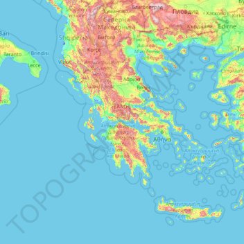
Name: Greece topographic map, elevation, terrain.
Location: Greece (34.71889 19.11275 41.74889 29.68381)
Average elevation: 170 m
Minimum elevation: -7 m
Maximum elevation: 2,734 m
Eighty percent of Greece consists of mountains or hills, making the country one of the most mountainous in Europe. Mount Olympus, the mythical abode of the Greek Gods, culminates at Mytikas peak 2,918 metres (9,573 ft), the highest in the country. Western Greece contains a number of lakes and wetlands and is dominated by the Pindus mountain range. The Pindus, a continuation of the Dinaric Alps, reaches a maximum elevation of 2,637 m (8,652 ft) at Mt. Smolikas (the second-highest in Greece) and historically has been a significant barrier to east–west travel.
Other topographic maps
Click on a map to view its topography, its elevation and its terrain.
Vancouver
Canada > British Columbia > Metro Vancouver Regional District
Vancouver, Metro Vancouver Regional District, British Columbia, Canada
Average elevation: 34 m
Canada
Canada
Average elevation: 254 m
Colorado Springs
United States > Colorado > El Paso County
Colorado Springs, El Paso County, Colorado, United States
Average elevation: 2,252 m
Edmonton
Canada > Alberta > Division No. 11
Edmonton, Division No. 11, Alberta, Canada
Average elevation: 690 m
Winnipeg
Canada > Manitoba > Division No. 11
Winnipeg, Division No. 11, Manitoba, Canada
Average elevation: 236 m
Victoria
Canada > British Columbia > Capital Regional District
Victoria, Capital Regional District, British Columbia, Canada
Average elevation: 17 m
Montreal
Canada > Quebec > Urban agglomeration of Montreal
Montreal, Urban agglomeration of Montreal, Montreal (administrative region), Quebec, Canada
Average elevation: 29 m
Surrey
Canada > British Columbia > Metro Vancouver Regional District
Surrey, Metro Vancouver Regional District, British Columbia, Canada
Average elevation: 28 m
Vancouver Island
Vancouver Island, British Columbia, Canada
Average elevation: 411 m
Westchester County
Westchester County, New York, United States
Average elevation: 95 m
Metro Vancouver Regional District
Metro Vancouver Regional District, British Columbia, Canada
Average elevation: 343 m
Saskatoon
Canada > Saskatchewan > Division No. 11
Saskatoon, Division No. 11, Saskatchewan, Canada
Average elevation: 504 m
Gaylord
United States > Michigan > Otsego County > Gaylord
Gaylord, Otsego County, Michigan, United States
Average elevation: 401 m
Coquitlam
Canada > British Columbia > Metro Vancouver Regional District
Coquitlam, Metro Vancouver Regional District, British Columbia, Canada
Average elevation: 190 m
Yellowstone National Park
Yellowstone National Park, Wyoming, United States
Average elevation: 2,450 m
Nanaimo
Canada > British Columbia > Regional District of Nanaimo
Nanaimo, Regional District of Nanaimo, British Columbia, Canada
Average elevation: 110 m
Hernando County
Hernando County, Florida, United States
Average elevation: 18 m
Lubbock
United States > Texas > Lubbock County
Lubbock, Lubbock County, Texas, United States
Average elevation: 983 m
Waterloo
Canada > Ontario > Region of Waterloo
Waterloo, Region of Waterloo, Ontario, Canada
Average elevation: 341 m
Niagara Falls
Canada > Ontario > Niagara Region
Niagara Falls, Niagara Region, Golden Horseshoe, Ontario, Canada
Average elevation: 179 m
Long Beach
United States > California > Los Angeles County
Long Beach, Los Angeles County, California, United States
Average elevation: 12 m
West Vancouver
Canada > British Columbia > Metro Vancouver Regional District
West Vancouver, Metro Vancouver Regional District, British Columbia, Canada
Average elevation: 384 m
Oak Bay
Canada > British Columbia > Capital Regional District
Oak Bay, Capital Regional District, British Columbia, Canada
Average elevation: 17 m
Białystok
Poland > Podlaskie Voivodeship
Białystok, Podlaskie Voivodeship, Poland
Average elevation: 140 m
Kitchener
Canada > Ontario > Region of Waterloo
Kitchener, Region of Waterloo, Southwestern Ontario, Ontario, Canada
Average elevation: 336 m
Galveston
United States > Texas > Galveston County
Galveston, Galveston County, Texas, United States
Average elevation: 1 m