
Karaj topographic map
Interactive map
Click on the map to display elevation.
About this map
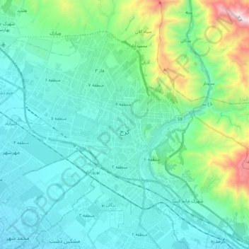
Name: Karaj topographic map, elevation, terrain.
Average elevation: 1,505 m
Minimum elevation: 1,212 m
Maximum elevation: 2,860 m
Other topographic maps
Click on a map to view its topography, its elevation and its terrain.
Mehrshahr
Iran > Alborz Province > Karaj > Mehrshahr
Mehrshahr, Karaj, بخش مرکزی شهرستان کرج, Alborz Province, مهرشهر, Iran
Average elevation: 1,255 m
Hesarak
Iran > Alborz Province > Karaj
Hesarak, Karaj, بخش مرکزی شهرستان کرج, Alborz Province, 31988, Iran
Average elevation: 1,284 m