
Whitley County topographic map
Interactive map
Click on the map to display elevation.
About this map
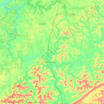
Name: Whitley County topographic map, elevation, terrain.
Location: Whitley County, Kentucky, United States (36.58776 -84.35613 36.97242 -83.87769)
Average elevation: 368 m
Minimum elevation: 206 m
Maximum elevation: 748 m
Whitley County is located within the Cumberland Plateau of southeastern Kentucky, which is greatly overlapped by the broad Eastern Coal Field region of the state. Because of its location in the midst of Cumberland Mountains, elevations in the county range from 723 to 2,220 feet (220 to 677 m) above sea level. 38,000 acres (150 km2) of western Whitley County are preserved within the Daniel Boone National Forest. Cumberland Falls, in Cumberland Falls State Resort Park, is the largest waterfall in Kentucky. Both Daniel Boone Forest and Cumberland Falls State Park are operated by the Kentucky State Parks system, also located in the county. The county contains two regionally significant waterways, the Laurel and Cumberland rivers.
Other topographic maps
Click on a map to view its topography, its elevation and its terrain.
Louisville
United States > Kentucky > Jefferson County
Louisville, Jefferson County, Kentucky, United States
Average elevation: 188 m
Zion Hill
United States > Kentucky > Scott County
Zion Hill, Scott County, Kentucky, United States
Average elevation: 260 m
Confluence
United States > Kentucky > Leslie County
Confluence, Leslie County, Kentucky, United States
Average elevation: 336 m
Hopkinsville
United States > Kentucky > Christian County
Hopkinsville, Christian County, Kentucky, 42240, United States
Average elevation: 171 m
Robinson Creek
United States > Kentucky > Pike County
Robinson Creek, Pike County, Kentucky, 41560, United States
Average elevation: 337 m
Crittenden County
Crittenden County, Kentucky, United States
Average elevation: 141 m
Redhouse
United States > Kentucky > Madison County
Redhouse, Madison County, Kentucky, United States
Average elevation: 248 m
New
United States > Kentucky > Owen County
New, Owen County, Kentucky, United States
Average elevation: 243 m
Horse Cave
United States > Kentucky > Hart County
Horse Cave, Hart County, Kentucky, United States
Average elevation: 207 m
Winchester
United States > Kentucky > Clark County
Winchester, Clark County, Kentucky, United States
Average elevation: 296 m
Bardstown
United States > Kentucky > Nelson County
Bardstown, Nelson County, Kentucky, 40004, United States
Average elevation: 199 m
Eastern
United States > Kentucky > Floyd County
Eastern, Floyd County, Kentucky, 41622, United States
Average elevation: 274 m
Lynch
United States > Kentucky > Harlan County
Lynch, Harlan County, Kentucky, United States
Average elevation: 770 m
Pikeville
United States > Kentucky > Pike County
Pikeville, Pike County, Kentucky, United States
Average elevation: 338 m
Mullins Point
United States > Kentucky > Wolfe County
Mullins Point, Wolfe County, Kentucky, United States
Average elevation: 289 m
Clark County
Clark County, Kentucky, 40391, United States
Average elevation: 273 m
Mentor
United States > Kentucky > Campbell County
Mentor, Campbell County, Kentucky, United States
Average elevation: 176 m
Holiday Hills
United States > Kentucky > Fayette County > Lexington
Holiday Hills, Lexington, Fayette County, Kentucky, United States
Average elevation: 287 m
Moorland
United States > Kentucky > Jefferson County > Lyndon
Moorland, Lyndon, Jefferson County, Kentucky, 40242, United States
Average elevation: 193 m
Cave City
United States > Kentucky > Barren County
Cave City, Barren County, Kentucky, United States
Average elevation: 207 m
Metcalfe County
Metcalfe County, Kentucky, United States
Average elevation: 251 m
Harlan County
United States > Kentucky > Harlan County
Harlan County, Kentucky, United States
Average elevation: 560 m
Water Valley
United States > Kentucky > Graves County
Water Valley, Graves County, Kentucky, 42085, United States
Average elevation: 122 m
Pineville
United States > Kentucky > Bell County > Pineville > Pineville
Pineville, Bell County, Kentucky, 40977, United States
Average elevation: 453 m
Murray
United States > Kentucky > Murray
Murray, Calloway County, Kentucky, United States
Average elevation: 159 m
Frankfort
United States > Kentucky > Franklin County
Frankfort, Franklin County, Kentucky, United States
Average elevation: 216 m
Slade
United States > Kentucky > Powell County > Slade
Slade, Powell County, Kentucky, 40376, United States
Average elevation: 311 m
Coldstream
United States > Kentucky > Jefferson County
Coldstream, Jefferson County, Kentucky, United States
Average elevation: 219 m
Aspen Grove
United States > Kentucky > Campbell County > Aspen Grove
Aspen Grove, Campbell County, Kentucky, 41001, United States
Average elevation: 226 m
Fairway
United States > Kentucky > Fayette County > Lexington > Fairway
Fairway, Lexington, Fayette County, Kentucky, United States
Average elevation: 314 m
Whitaker
United States > Kentucky > Letcher County > Whitaker
Whitaker, Letcher County, Kentucky, 41849, United States
Average elevation: 469 m
Kingston
United States > Kentucky > Lexington > Kingston
Kingston, Joyland, Lexington, Fayette County, Kentucky, 40505, United States
Average elevation: 297 m
Bullitt County
Bullitt County, Kentucky, United States
Average elevation: 183 m
Highgate Springs
United States > Kentucky > Louisville > Highgate Springs
Highgate Springs, Louisville, Jefferson County, Kentucky, 40220, United States
Average elevation: 161 m
Buckhorn Lake
United States > Kentucky > Perry County
Buckhorn Lake, Perry County, Kentucky, United States
Average elevation: 352 m
Buckhorn
United States > Kentucky > Buckhorn
Buckhorn, Perry County, Kentucky, United States
Average elevation: 307 m
Sandy Hook
United States > Kentucky > Sandy Hook
Sandy Hook, Elliott County, Kentucky, United States
Average elevation: 261 m
Prospect
United States > Kentucky > Jefferson County
Prospect, Jefferson County, Kentucky, United States
Average elevation: 166 m
Beaver Dam
United States > Kentucky > Ohio County
Beaver Dam, Ohio County, Kentucky, 42320, United States
Average elevation: 131 m
Lexington
United States > Kentucky > Fayette County
Lexington, Fayette County, Kentucky, United States
Average elevation: 281 m
Pitts Point
United States > Kentucky > Pitts Point
Pitts Point, Bullitt County, Kentucky, United States
Average elevation: 155 m
Alexandria
United States > Kentucky > Campbell County
Alexandria, Campbell County, Kentucky, United States
Average elevation: 220 m
Thornhill
United States > Kentucky > Jefferson County
Thornhill, Jefferson County, Kentucky, United States
Average elevation: 180 m
Mount Sterling
United States > Kentucky > Montgomery County
Mount Sterling, Montgomery County, Kentucky, 40353, United States
Average elevation: 299 m