
Majuli topographic map
Interactive map
Click on the map to display elevation.
About this map
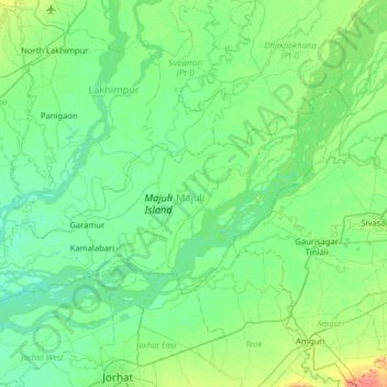
Name: Majuli topographic map, elevation, terrain.
Location: Majuli, Assam, 785104, India (26.86653 93.95991 27.18552 94.59583)
Average elevation: 90 m
Minimum elevation: 73 m
Maximum elevation: 169 m
Other topographic maps
Click on a map to view its topography, its elevation and its terrain.
Barangajuli
India > Assam > Harisinga tehsil
Barangajuli, Harisinga tehsil, Udalguri District, Assam, 784526, India
Average elevation: 117 m
North Lakhimpur
North Lakhimpur, Lakhimpur, Assam, India
Average elevation: 92 m
Sarthebari
India > Assam > Sarthebari > Sarthebari
Sarthebari, Bajali, Assam, 781307, India
Average elevation: 41 m
Jorhat
India > Assam > Jorhat East
Jorhat, Jorhat East, Jorhat, Assam, 785001, India
Average elevation: 93 m
Dibrugarh West
India > Assam > Dibrugarh West
Dibrugarh West, Dibrugarh, Assam, India
Average elevation: 100 m