
City of Lockport topographic map
Interactive map
Click on the map to display elevation.
About this map
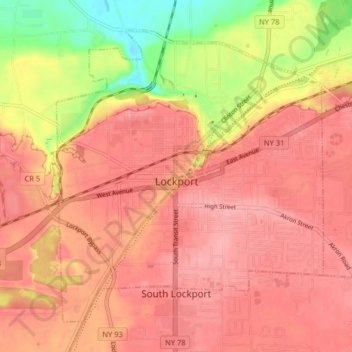
Name: City of Lockport topographic map, elevation, terrain.
Average elevation: 174 m
Minimum elevation: 106 m
Maximum elevation: 203 m
Other topographic maps
Click on a map to view its topography, its elevation and its terrain.
Rapids
United States > New York > Niagara County
Rapids, Town of Lockport, Niagara County, New York, United States
Average elevation: 179 m
Town of Lewiston
United States > New York > Niagara County
Town of Lewiston, Niagara County, New York, United States
Average elevation: 134 m
Black Creek Village
United States > New York > Niagara County > City of Niagara Falls
Black Creek Village, City of Niagara Falls, Niagara County, New York, 14304, United States
Average elevation: 176 m
Village of Lewiston
United States > New York > Niagara County > Town of Lewiston
Village of Lewiston, Town of Lewiston, Town of Niagara, Niagara County, New York, United States
Average elevation: 122 m
City of Niagara Falls
United States > New York > Niagara County
City of Niagara Falls, Niagara County, New York, United States
Average elevation: 180 m
Niagara Escarpment
United States > New York > Niagara County > City of Lockport
Niagara Escarpment, City of Lockport, Town of Lockport, Niagara County, New York, 14094, United States
Average elevation: 165 m
Shooktown
United States > New York > Niagara County > City of Lockport
Shooktown, City of Lockport, Town of Lockport, Niagara County, New York, 14094, United States
Average elevation: 191 m
Lewiston Heights
United States > New York > Niagara County > Town of Lewiston > Village of Lewiston
Lewiston Heights, Village of Lewiston, Town of Lewiston, Town of Niagara, Niagara County, New York, 14092, United States
Average elevation: 144 m