
Red Lake County topographic map
Interactive map
Click on the map to display elevation.
About this map
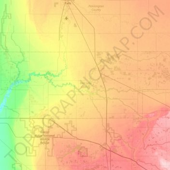
Name: Red Lake County topographic map, elevation, terrain.
Location: Red Lake County, Minnesota, United States (47.75957 -96.48255 47.96464 -95.70915)
Average elevation: 341 m
Minimum elevation: 268 m
Maximum elevation: 419 m
The Red Lake River flows southward into the county from Pennington. It is joined near Red Lake Falls by the Clearwater River; the combined flow (still known as the Red Lake River) flows southwestward to Huot, where it is augmented by the Black River which drains the NW part of the county. The Red Lake River then flows southwestward into Polk County. The county terrain consists of low rolling hills, etched by drainages and gullies. The area is devoted to agriculture. The county terrain slopes to the west, with its highest elevation on its SE corner, at 1,201' (366m) ASL. The county has a total area of 432 square miles (1,120 km2), of which 432 square miles (1,120 km2) is land and 0.09 square miles (0.23 km2) (0.02%) is water.
Other topographic maps
Click on a map to view its topography, its elevation and its terrain.
Coffee Creek
United States > Minnesota > Lake County
Coffee Creek, Lake No. 1, Lake County, Minnesota, United States
Average elevation: 521 m
Edina
United States > Minnesota > Hennepin County
Edina, Hennepin County, Minnesota, United States
Average elevation: 271 m
Apple Valley
United States > Minnesota > Dakota County
Apple Valley, Dakota County, Minnesota, 55124, United States
Average elevation: 301 m
Ernest Lake
United States > Minnesota > Cook County
Ernest Lake, West Cook, Cook County, Minnesota, United States
Average elevation: 505 m
Sandstone
United States > Minnesota > Pine County
Sandstone, Pine County, Minnesota, United States
Average elevation: 332 m
Lakeville
United States > Minnesota > Dakota County
Lakeville, Dakota County, Minnesota, 55044, United States
Average elevation: 305 m
St. James
United States > Minnesota > Watonwan County
St. James, Watonwan County, Minnesota, 56081, United States
Average elevation: 328 m
Carey Creek
United States > Minnesota > Olmsted County
Carey Creek, Olmsted County, Minnesota, 55976, United States
Average elevation: 375 m
Alice Lake
United States > Minnesota > Lake County
Alice Lake, Fall Lake Township, Lake County, Minnesota, United States
Average elevation: 474 m
Sea Gull Lake
United States > Minnesota > Cook County
Sea Gull Lake, West Cook, Cook County, Minnesota, United States
Average elevation: 460 m
Courtland
United States > Minnesota > Nicollet County
Courtland, Nicollet County, Minnesota, 56021, United States
Average elevation: 281 m
Edna Lake
United States > Minnesota > Aitkin County
Edna Lake, Aitkin County, Minnesota, United States
Average elevation: 411 m
Barnes Lake
United States > Minnesota > Carver County > Norwood Young America
Barnes Lake, Norwood Young America, Young America Township, Carver County, Minnesota, United States
Average elevation: 300 m
Elk River
United States > Minnesota > Sherburne County
Elk River, Sherburne County, Minnesota, 55330, United States
Average elevation: 283 m
Lake Itasca
United States > Minnesota > Clearwater County
Lake Itasca, Clearwater County, Minnesota, United States
Average elevation: 463 m
Link Lake
United States > Minnesota > Lake County
Link Lake, Lake County, Minnesota, United States
Average elevation: 452 m
Howard Lake
United States > Minnesota > Wright County
Howard Lake, Wright County, Minnesota, 55349, United States
Average elevation: 312 m
Babbitt
United States > Minnesota > Saint Louis County
Babbitt, Saint Louis County, Minnesota, United States
Average elevation: 484 m
McGrath
United States > Minnesota > Aitkin County
McGrath, Aitkin County, Minnesota, United States
Average elevation: 379 m
Bloomington
United States > Minnesota > Hennepin County
Bloomington, Hennepin County, Minnesota, United States
Average elevation: 255 m
Ash Lake
United States > Minnesota > Saint Louis County
Ash Lake, Saint Louis County, Minnesota, United States
Average elevation: 413 m
Lakefield
United States > Minnesota > Jackson County
Lakefield, Jackson County, Minnesota, United States
Average elevation: 450 m
East Gull Lake
United States > Minnesota > Cass County
East Gull Lake, Cass County, Minnesota, United States
Average elevation: 370 m
Finlayson
United States > Minnesota > Pine County
Finlayson, Pine County, Minnesota, United States
Average elevation: 339 m
Lake Elmo
United States > Minnesota > Washington County
Lake Elmo, Washington County, Minnesota, 55042, United States
Average elevation: 287 m
North Shore Mining/Lake Superior Overlook
United States > Minnesota > Lake County > Silver Bay
North Shore Mining/Lake Superior Overlook, City Shop Road, Silver Bay, Lake County, Minnesota, 55614, United States
Average elevation: 252 m
Beauty Lake
United States > Minnesota > Kanabec County
Beauty Lake, Kanabec County, Minnesota, United States
Average elevation: 347 m
Grand Rapids
United States > Minnesota > Itasca County
Grand Rapids, Itasca County, Minnesota, 55744, United States
Average elevation: 398 m
Fosston
United States > Minnesota > Polk County
Fosston, Polk County, Minnesota, 56542, United States
Average elevation: 393 m
Lanesboro
United States > Minnesota > Fillmore County
Lanesboro, Fillmore County, Minnesota, 55949, United States
Average elevation: 299 m
Byron
United States > Minnesota > Olmsted County
Byron, Olmsted County, Minnesota, 55920, United States
Average elevation: 365 m
Wren Lake
United States > Minnesota > Cass County
Wren Lake, Cass County, Minnesota, United States
Average elevation: 418 m
Shorewood
United States > Minnesota > Hennepin County
Shorewood, Hennepin County, Minnesota, United States
Average elevation: 289 m
Faribault County
Faribault County, Minnesota, United States
Average elevation: 340 m
Rainy River
United States > Minnesota > Koochiching County
Rainy River, Koochiching County, Minnesota, 56629, United States
Average elevation: 341 m
Gooseberry Lake
United States > Minnesota > Cass County
Gooseberry Lake, Cass County, Minnesota, United States
Average elevation: 418 m
Marshall Lake
United States > Minnesota > Cook County
Marshall Lake, West Cook, Cook County, Minnesota, United States
Average elevation: 556 m
Cream Lake
United States > Minnesota > Cook County
Cream Lake, West Cook, Cook County, Minnesota, United States
Average elevation: 574 m
Duck Lake
United States > Minnesota > Crow Wing County > Crosslake
Duck Lake, Crosslake, Crow Wing County, Minnesota, United States
Average elevation: 377 m
George Lake
United States > Minnesota > Cook County
George Lake, West Cook, Cook County, Minnesota, United States
Average elevation: 551 m
Little Swan
United States > Minnesota > Saint Louis County > Hibbing
Little Swan, Hibbing, Saint Louis County, Minnesota, United States
Average elevation: 395 m
Zumbrota
United States > Minnesota > Goodhue County
Zumbrota, Goodhue County, Minnesota, 55992, United States
Average elevation: 312 m
Skyline
United States > Minnesota > Blue Earth County
Skyline, Blue Earth County, Minnesota, United States
Average elevation: 265 m
Bull Lake
United States > Minnesota > Cook County
Bull Lake, West Cook, Cook County, Minnesota, United States
Average elevation: 571 m
Jimmy Lake
United States > Minnesota > Cook County
Jimmy Lake, West Cook, Cook County, Minnesota, United States
Average elevation: 489 m
Benson Lake
United States > Minnesota > Cook County
Benson Lake, East Cook, Cook County, Minnesota, United States
Average elevation: 505 m
Becker County
Becker County, Minnesota, United States
Average elevation: 439 m
Lucan
United States > Minnesota > Redwood County
Lucan, Redwood County, Minnesota, United States
Average elevation: 331 m