
Lulworth Cove topographic map
Interactive map
Click on the map to display elevation.
About this map
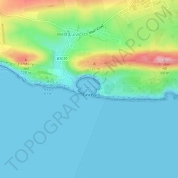
Name: Lulworth Cove topographic map, elevation, terrain.
Average elevation: 37 m
Minimum elevation: 0 m
Maximum elevation: 163 m
Other topographic maps
Click on a map to view its topography, its elevation and its terrain.
Durdle Door
United Kingdom > England > West Lulworth
Durdle Door, Britwell Drive, West Lulworth, Dorset, South West England, England, BH20 5RS, United Kingdom
Average elevation: 48 m
West Lulworth
United Kingdom > England > West Lulworth
West Lulworth, Dorset, South West England, England, BH20 5FD, United Kingdom
Average elevation: 68 m