
Bornholm topographic map
Interactive map
Click on the map to display elevation.
About this map
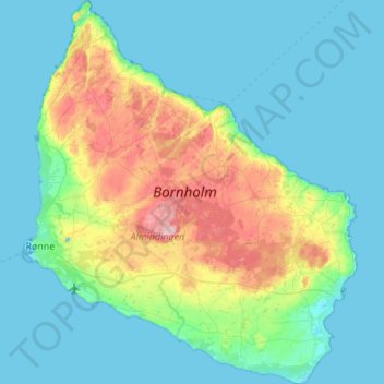
Name: Bornholm topographic map, elevation, terrain.
Location: Bornholm, Capital Region of Denmark, Denmark (54.98724 14.67920 55.29912 15.15692)
Average elevation: 33 m
Minimum elevation: -1 m
Maximum elevation: 162 m
The island is known as solskinsøen (Sunshine Island) because of its weather and klippeøen (Rock Island) because of its geology, which consists of granite, except along the southern coast. The heat from the summer is stored in the rock formations and the weather is quite warm until October. As a result of the climate, a local variety of the common fig, known as Bornholm's Diamond, can grow locally on the island. The island's topography consists of dramatic rock formations in the north (unlike the rest of Denmark, which is mostly gentle rolling hills) sloping down towards pine and deciduous forests (greatly affected by storms in the 1950s), farmland in the middle and sandy beaches in the south.
Other topographic maps
Click on a map to view its topography, its elevation and its terrain.
Birkerød
Denmark > Capital Region of Denmark
Birkerød, Rudersdal Municipality, Capital Region of Denmark, 3460, Denmark
Average elevation: 40 m
Kongens Lyngby
Denmark > Capital Region of Denmark
Kongens Lyngby, Lyngby-Taarbæk Municipality, Capital Region of Denmark, 2800, Denmark
Average elevation: 29 m
Frederiksberg
Denmark > Capital Region of Denmark
Frederiksberg, Frederiksberg Municipality, Capital Region of Denmark, 1861, Denmark
Average elevation: 11 m
Nexø
Denmark > Capital Region of Denmark
Nexø, Bornholms Regionskommune, Capital Region of Denmark, 3730, Denmark
Average elevation: 13 m
Gudhjem
Denmark > Capital Region of Denmark > Gudhjem
Gudhjem, Bornholms Regionskommune, Capital Region of Denmark, 3760, Denmark
Average elevation: 19 m
Copenhagen
Denmark > Capital Region of Denmark
Copenhagen, Copenhagen Municipality, Capital Region of Denmark, 1357, Denmark
Average elevation: 9 m
Hundested
Denmark > Capital Region of Denmark > Hundested
Hundested, Halsnæs Municipality, Capital Region of Denmark, 3390, Denmark
Average elevation: 2 m
Høsterkøb
Denmark > Capital Region of Denmark > Høsterkøb
Høsterkøb, Rudersdal Municipality, Capital Region of Denmark, 2970, Denmark
Average elevation: 45 m
Gladsaxe Municipality
Denmark > Capital Region of Denmark
Gladsaxe Municipality, Capital Region of Denmark, Denmark
Average elevation: 30 m
Albertslund Municipality
Denmark > Capital Region of Denmark
Albertslund Municipality, Capital Region of Denmark, 2620, Denmark
Average elevation: 18 m
Viberup
Denmark > Capital Region of Denmark > Viberup
Viberup, Tårnby Kommune, Capital Region of Denmark, 2770, Denmark
Average elevation: 1 m
Fredensborg
Denmark > Capital Region of Denmark > Fredensborg
Fredensborg, Fredensborg Municipality, Capital Region of Denmark, 3480, Denmark
Average elevation: 27 m
Frederiksberg Municipality
Denmark > Capital Region of Denmark
Frederiksberg Municipality, Capital Region of Denmark, Denmark
Average elevation: 15 m