
Shreveport topographic map
Interactive map
Click on the map to display elevation.
About this map
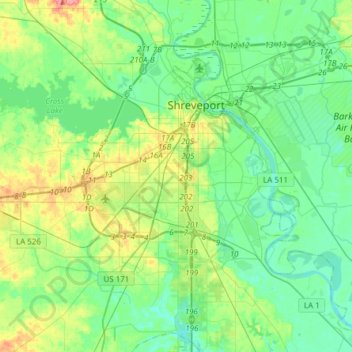
Name: Shreveport topographic map, elevation, terrain.
Location: Shreveport, Caddo Parish, Louisiana, United States (32.33269 -93.94785 32.58987 -93.67972)
Average elevation: 58 m
Minimum elevation: 38 m
Maximum elevation: 112 m
Shreveport is the parish seat of Caddo Parish. Portions of the city extend into neighboring Bossier Parish, bordering Bossier City. Shreveport sits on a low elevation overlooking the Red River. Western and northern portions of Shreveport have an elevation over 253 feet (77 m) above sea level. Pine forests, cotton fields, wetlands, and waterways mark the outskirts of the city. According to the United States Census Bureau in 2010, the city had a total area of 122.35 sq mi (316.88 km2), of which 107.14 sq mi (277.48 km2) is land and 15.21 sq mi (39.40 km2) is water.
Other topographic maps
Click on a map to view its topography, its elevation and its terrain.
Caspiana
United States > Louisiana > Caddo Parish
Caspiana, Caddo Parish, Louisiana, 71115, United States
Average elevation: 44 m