
Mitikas topographic map
Interactive map
Click on the map to display elevation.
About this map
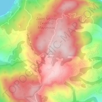
Name: Mitikas topographic map, elevation, terrain.
Average elevation: 261 m
Minimum elevation: 0 m
Maximum elevation: 423 m
Other topographic maps
Click on a map to view its topography, its elevation and its terrain.
Metamorfosi
Greece > Thessaly and Central Greece > Karditsa Regional Unit
Metamorfosi, Palamas Municipality, Karditsa Regional Unit, Thessaly, Thessaly and Central Greece, 432 00, Greece
Average elevation: 98 m
Larissa
Greece > Thessaly and Central Greece > Larisa Regional Unit
Larissa, Municipal Unit of Larissa, Municipality of Larissa, Larisa Regional Unit, Thessaly, Thessaly and Central Greece, 422 22, Greece
Average elevation: 128 m
Euboea
Greece > Thessaly and Central Greece
Euboea, Thessaly and Central Greece, Greece
Average elevation: 113 m
Municipal Unit of Delphi
Greece > Thessaly and Central Greece > Regional Unit of Phocis
Municipal Unit of Delphi, Delphi Municipality, Regional Unit of Phocis, Central Greece, Thessaly and Central Greece, 330 54, Greece
Average elevation: 693 m
Lamia
Greece > Thessaly and Central Greece > Phthiotis Regional Unit > Lamia
Lamia, Phthiotis Regional Unit, Central Greece, Thessaly and Central Greece, 35100, Greece
Average elevation: 533 m
Klima
Greece > Thessaly and Central Greece > Klima
Klima, Skopelos Municipality, Sporades Regional Unit, Thessaly, Thessaly and Central Greece, 37004, Greece
Average elevation: 114 m
Volos Municipality
Greece > Thessaly and Central Greece > Volos Municipality
Volos Municipality, Regional Unit of Magnesia, Thessaly, Thessaly and Central Greece, Greece
Average elevation: 228 m
Karpenisi
Greece > Thessaly and Central Greece > Karpenisi
Karpenisi, Δήμος Καρπενησίου, Regional Unit of Evrytania, Central Greece, Thessaly and Central Greece, 36100, Greece
Average elevation: 1,236 m
Skiathos
Greece > Thessaly and Central Greece
Skiathos, Skiathos Municipality, Sporades Regional Unit, Thessaly, Thessaly and Central Greece, 37002, Greece
Average elevation: 44 m
Λουτρά Θερμοπυλών
Greece > Thessaly and Central Greece > Λουτρά Θερμοπυλών
Λουτρά Θερμοπυλών, Lamia, Phthiotis Regional Unit, Central Greece, Thessaly and Central Greece, 35009, Greece
Average elevation: 241 m
Dytiki Soufla
Greece > Thessaly and Central Greece > Regional Unit of Phocis > Municipal Unit of Vardousia
Dytiki Soufla, Municipal Unit of Vardousia, Dorida Municipality, Regional Unit of Phocis, Central Greece, Thessaly and Central Greece, Greece
Average elevation: 1,893 m