
Atlanta topographic map
Interactive map
Click on the map to display elevation.
About this map
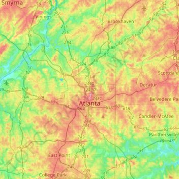
Name: Atlanta topographic map, elevation, terrain.
Location: Atlanta, Fulton County, Georgia, United States (33.64781 -84.55107 33.88682 -84.28956)
Average elevation: 284 m
Minimum elevation: 225 m
Maximum elevation: 358 m
Atlanta is rated as a "beta+" world city that exerts a moderate impact on global commerce, finance, research, technology, education, media, art, and entertainment. It ranks in the top twenty among world cities and 10th in the nation with a gross domestic product (GDP) of $385 billion. Atlanta's economy is considered diverse, with dominant sectors that include aerospace, transportation, logistics, professional and business services, media operations, medical services, and information technology. Atlanta has topographic features that include rolling hills and dense tree coverage, earning it the nickname of "the city in a forest." Revitalization of Atlanta's neighborhoods, initially spurred by the 1996 Summer Olympics, has intensified in the 21st century, altering the city's demographics, politics, aesthetics, and culture.
Other topographic maps
Click on a map to view its topography, its elevation and its terrain.
Roswell
United States > Georgia > Fulton County
Roswell, Fulton County, Georgia, United States
Average elevation: 316 m
Johns Creek
United States > Georgia > Fulton County > Johns Creek
Johns Creek, Fulton County, Georgia, 30097, United States
Average elevation: 305 m
Atlanta
United States > Georgia > Fulton County
Atlanta, Fulton County, Georgia, 30303, United States
Average elevation: 285 m
Milton
United States > Georgia > Fulton County
Milton, Fulton County, Georgia, 30004, United States
Average elevation: 330 m
Fort McPherson
United States > Georgia > Fulton County > Atlanta
Fort McPherson, Atlanta, Fulton County, Georgia, 30330, United States
Average elevation: 309 m
Fairburn
United States > Georgia > Fulton County > Fairburn
Fairburn, Fulton County, Georgia, 30213, United States
Average elevation: 293 m
Mountain Park
United States > Georgia > Fulton County > Mountain Park
Mountain Park, Fulton County, Georgia, United States
Average elevation: 312 m