
Central Province topographic map
Interactive map
Click on the map to display elevation.
About this map
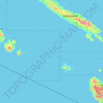
Name: Central Province topographic map, elevation, terrain.
Location: Central Province, Solomon Islands (-9.29730 158.64945 -8.21139 160.72733)
Average elevation: 23 m
Minimum elevation: -1 m
Maximum elevation: 1,131 m
Other topographic maps
Click on a map to view its topography, its elevation and its terrain.
Mbanika
Solomon Islands > Central Province
Mbanika, Central Province, Solomon Islands
Average elevation: 22 m
Nggela Sule
Solomon Islands > Central Province
Nggela Sule, Central Province, Solomon Islands
Average elevation: 33 m
Pavuvu
Solomon Islands > Central Province
Pavuvu, Central Province, Solomon Islands
Average elevation: 26 m