
Wrocław topographic map
Interactive map
Click on the map to display elevation.
About this map
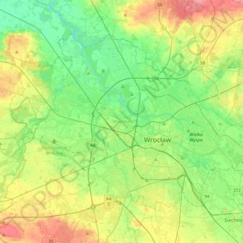
Name: Wrocław topographic map, elevation, terrain.
Location: Wrocław, Lower Silesian Voivodeship, Poland (51.04267 16.80734 51.21006 17.17622)
Average elevation: 125 m
Minimum elevation: 99 m
Maximum elevation: 170 m
Other topographic maps
Click on a map to view its topography, its elevation and its terrain.
Wroclaw
Poland > Lower Silesian Voivodeship > Wrocław > Wroclaw
Wroclaw, Wrocław, Lower Silesian Voivodeship, 50-001, Poland
Average elevation: 130 m
Osiedle Borek
Poland > Lower Silesian Voivodeship > Wrocław
Osiedle Borek, Wrocław, Lower Silesian Voivodeship, Poland
Average elevation: 125 m