
Minneapolis topographic map
Interactive map
Click on the map to display elevation.
About this map
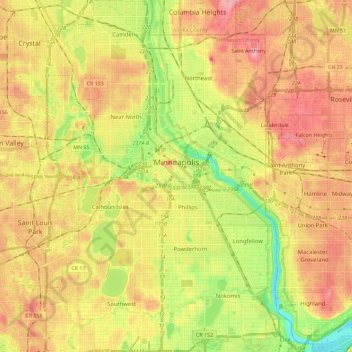
Name: Minneapolis topographic map, elevation, terrain.
Location: Minneapolis, Hennepin County, Minnesota, United States (44.89015 -93.32913 45.05125 -93.19386)
Average elevation: 270 m
Minimum elevation: 211 m
Maximum elevation: 318 m
The city center is located at 45° N latitude. The city's lowest elevation of 686 feet (209 m) is near where Minnehaha Creek meets the Mississippi River. The site of the Prospect Park Water Tower is often cited as the city's highest point and a placard in Deming Heights Park denotes the highest elevation. A spot at 974 feet (297 m) in or near Waite Park in Northeast Minneapolis, however, is corroborated by Google Earth as the highest ground.
Other topographic maps
Click on a map to view its topography, its elevation and its terrain.
Edina
United States > Minnesota > Hennepin County
Edina, Hennepin County, Minnesota, United States
Average elevation: 271 m
Bloomington
United States > Minnesota > Hennepin County
Bloomington, Hennepin County, Minnesota, United States
Average elevation: 255 m
Shorewood
United States > Minnesota > Hennepin County
Shorewood, Hennepin County, Minnesota, United States
Average elevation: 289 m
St. Anthony
United States > Minnesota > Hennepin County
St. Anthony, Hennepin County, Minnesota, United States
Average elevation: 286 m
Minneapolis
United States > Minnesota > Hennepin County > Minneapolis
Minneapolis, Hennepin County, Minnesota, 55488, United States
Average elevation: 271 m
Saint Louis Park
United States > Minnesota > Hennepin County > Saint Louis Park
Saint Louis Park, Hennepin County, Minnesota, United States
Average elevation: 275 m
Long Lake
United States > Minnesota > Hennepin County
Long Lake, Hennepin County, Minnesota, 55356, United States
Average elevation: 300 m
Crystal
United States > Minnesota > Hennepin County
Crystal, Hennepin County, Minnesota, 55429, United States
Average elevation: 273 m
Eden Prairie
United States > Minnesota > Hennepin County
Eden Prairie, Hennepin County, Minnesota, United States
Average elevation: 259 m