
Gothenburg topographic map
Interactive map
Click on the map to display elevation.
About this map
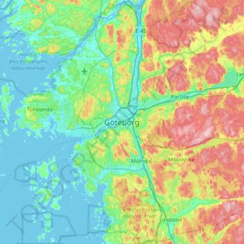
Name: Gothenburg topographic map, elevation, terrain.
Average elevation: 45 m
Minimum elevation: -4 m
Maximum elevation: 158 m
Other topographic maps
Click on a map to view its topography, its elevation and its terrain.
Kallebäck
Sweden > Västra Götaland County
Kallebäck, Centrum, Göteborgs Stad, Västra Götaland County, Sweden
Average elevation: 52 m
Vara kommun
Sweden > Västra Götaland County
Vara kommun, Västra Götaland County, Sweden
Average elevation: 102 m
Dalarna
Sweden > Västra Götaland County > Dalarna
Dalarna, Strömstads kommun, Västra Götaland County, Sweden
Average elevation: 72 m