
Bowen Island topographic map
Interactive map
Click on the map to display elevation.
About this map
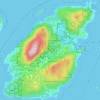
Name: Bowen Island topographic map, elevation, terrain.
Average elevation: 106 m
Minimum elevation: -1 m
Maximum elevation: 718 m
Other topographic maps
Click on a map to view its topography, its elevation and its terrain.
Howe Sound
Canada > British Columbia > Metro Vancouver Regional District > Bowen Island Municipality > Gibsons
Howe Sound, Gibsons, Bowen Island Municipality, Metro Vancouver Regional District, British Columbia, V8B 0A6, Canada
Average elevation: 529 m