
Telluride topographic map
Interactive map
Click on the map to display elevation.
About this map
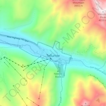
Name: Telluride topographic map, elevation, terrain.
Average elevation: 3,125 m
Minimum elevation: 2,647 m
Maximum elevation: 4,023 m
Telluride has an elevation of 8,750 feet (2,670 m) in an isolated spot in Southwest Colorado. From the west, Colorado Route 145 is the most common way into Telluride; two other passes enter the town, Imogene Pass and Black Bear Pass.
Other topographic maps
Click on a map to view its topography, its elevation and its terrain.
Dunn Peak
United States > Colorado > San Miguel County
Dunn Peak, San Miguel County, Colorado, United States
Average elevation: 3,487 m