
Council Bluffs topographic map
Interactive map
Click on the map to display elevation.
About this map
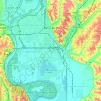
Name: Council Bluffs topographic map, elevation, terrain.
Location: Council Bluffs, Pottawattamie County, Iowa, United States (41.16725 -95.92725 41.29073 -95.75109)
Average elevation: 315 m
Minimum elevation: 291 m
Maximum elevation: 386 m
Other topographic maps
Click on a map to view its topography, its elevation and its terrain.
Loveland
United States > Iowa > Pottawattamie County
Loveland, Pottawattamie County, Iowa, United States
Average elevation: 330 m
Council Bluffs
United States > Iowa > Pottawattamie County > Council Bluffs
Council Bluffs, Pottawattamie County, Iowa, 51502, United States
Average elevation: 338 m