
Priest Lake topographic map
Interactive map
Click on the map to display elevation.
About this map
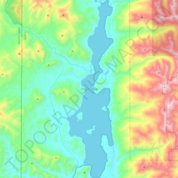
Name: Priest Lake topographic map, elevation, terrain.
Location: Priest Lake, Bonner County, Idaho, United States (48.47392 -116.92940 48.74521 -116.82205)
Average elevation: 1,123 m
Minimum elevation: 738 m
Maximum elevation: 2,221 m
Other topographic maps
Click on a map to view its topography, its elevation and its terrain.
Sandpoint
United States > Idaho > Bonner County
Sandpoint, Bonner County, Idaho, United States
Average elevation: 658 m
Hope
United States > Idaho > Bonner County
Hope, Bonner County, Idaho, United States
Average elevation: 763 m
Dover
United States > Idaho > Bonner County
Dover, Bonner County, Idaho, 83825, United States
Average elevation: 680 m
Priest River
United States > Idaho > Bonner County
Priest River, Bonner County, Idaho, United States
Average elevation: 742 m
Sagle
United States > Idaho > Bonner County
Sagle, Bonner County, Idaho, 83860, United States
Average elevation: 692 m
Pend Oreille River
United States > Idaho > Bonner County > Oldtown
Pend Oreille River, Oldtown, Bonner County, Idaho, 83822, United States
Average elevation: 657 m
Careywood
United States > Idaho > Bonner County
Careywood, Bonner County, Idaho, United States
Average elevation: 740 m
Ponderay
United States > Idaho > Bonner County
Ponderay, Bonner County, Idaho, 83852, United States
Average elevation: 652 m
Cedar Creek
United States > Idaho > Bonner County
Cedar Creek, Bonner County, Idaho, United States
Average elevation: 748 m
Kootenai
United States > Idaho > Bonner County
Kootenai, Bonner County, Idaho, 83840, United States
Average elevation: 641 m
Clark Fork
United States > Idaho > Bonner County
Clark Fork, Bonner County, Idaho, United States
Average elevation: 681 m
Sandpoint
United States > Idaho > Bonner County > Sandpoint
Sandpoint, Bonner County, Idaho, 83852, United States
Average elevation: 687 m
Blanchard
United States > Idaho > Bonner County
Blanchard, Bonner County, Idaho, 83804, United States
Average elevation: 718 m