
Likely topographic map
Interactive map
Click on the map to display elevation.
About this map
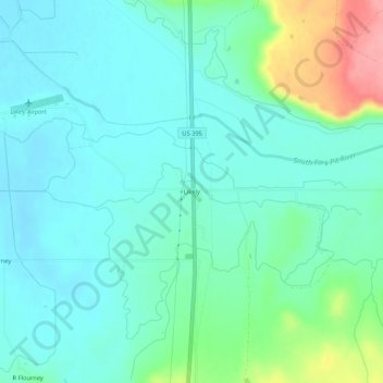
Name: Likely topographic map, elevation, terrain.
Location: Likely, Modoc County, California, 96116, United States (41.21045 -120.52412 41.25045 -120.48412)
Average elevation: 1,363 m
Minimum elevation: 1,338 m
Maximum elevation: 1,448 m
Likely (formerly, South Fork) is a census-designated place in Modoc County, California. It is located near the South Fork of the Pit River 18 miles (29 km) south of the county seat of Alturas, at an elevation of 4,449 feet (1,356 m). Located 6 miles (9.7 km) north-northwest of Likely Mountain, it is somewhat sheltered from prevailing southwesterly winds, and its microclimate is noticeably drier and less stormy than surrounding areas. The ZIP Code for the community is 96116.
Other topographic maps
Click on a map to view its topography, its elevation and its terrain.
White Horse
United States > California > Modoc County
White Horse, Modoc County, California, United States
Average elevation: 1,352 m
Lost Hill
United States > California > Modoc County
Lost Hill, Modoc County, California, United States
Average elevation: 1,553 m
Modoc County
United States > California > Modoc County
Modoc County, California, United States
Average elevation: 1,537 m