
North Brabant topographic map
Interactive map
Click on the map to display elevation.
About this map
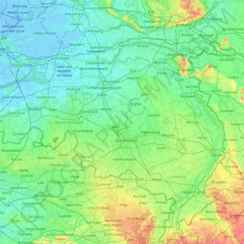
Name: North Brabant topographic map, elevation, terrain.
Location: North Brabant, Netherlands (51.22091 4.19012 51.83075 6.04812)
Average elevation: 22 m
Minimum elevation: -7 m
Maximum elevation: 158 m
The historical region of Kempen occupies the southern part of the province of Noord-Brabant and extends south of Eindhoven far into northern Belgium. To the east it reaches as far as the Meuse valley. The surface topography of De Kempen is very uniform. Most of it lies between 5m/15 ft and 35m/115 ft above sea level. The basement rocks are Cretaceous and Tertiary sediments, which are overlaid by Ice Age gravels and sands carried here by rivers of melt-water from the retreating glaciers. It is a typical area of sandy heathland. The infertile soil is suitable only for undemanding crops such as rye, oats, potatoes and fodder plants; this limits the profitability of agriculture. Until a few decades ago Kempen was a region of heathland and sand drifts with a sparse growth of pines, a few scattered villages subsisting on the poor soil and some small towns; and this is still the pattern in much of the region. In recent years, however, the rapid advance of industry has brought about profound changes in this agricultural region. The origins of this industrial development go back 70–100 years. The main concentrations of industry are along the southern frontier of the Netherlands, e.g., at Eindhoven, Helmond, Tilburg, Breda, 's-Hertogenbosch.
Other topographic maps
Click on a map to view its topography, its elevation and its terrain.
's-Hertogenbosch
's-Hertogenbosch, North Brabant, Netherlands
Average elevation: 4 m
Schellingwoude
Netherlands > North Holland > Amsterdam
Schellingwoude, Amsterdam, North Holland, Netherlands, 1023 NH, Netherlands
Average elevation: 1 m
Oosterwijzend
Netherlands > North Holland > Hoogkarspel
Oosterwijzend, Hoogkarspel, Drechterland, North Holland, Netherlands, 1616 CN, Netherlands
Average elevation: -2 m
Zuidbarge
Netherlands > Drenthe > Emmen
Zuidbarge, Emmen, Drenthe, Netherlands, 7825 TS, Netherlands
Average elevation: 20 m
Oud-Zevenaar
Netherlands > Gelderland > Zevenaar
Oud-Zevenaar, Zevenaar, Gelderland, Netherlands, 6905 AJ, Netherlands
Average elevation: 12 m
Purmerend
Netherlands > North Holland > Purmerend
Purmerend, North Holland, Netherlands
Average elevation: -2 m
Dutch Harbour
Netherlands > South Holland > 's-Gravendeel
Dutch Harbour, 's-Gravendeel, Hoeksche Waard, South Holland, Netherlands, 3295 XZ, Netherlands
Average elevation: 1 m
Hout
Netherlands > North Brabant > Geldrop
Hout, Geldrop, Geldrop-Mierlo, North Brabant, Netherlands, 5664 EW, Netherlands
Average elevation: 22 m
Den Burg
Den Burg, Texel, North Holland, Netherlands
Average elevation: 1 m
Zevenhuizen
Zevenhuizen, Zuidplas, South Holland, Netherlands
Average elevation: -4 m
Hillegom
Netherlands > South Holland > Hillegom
Hillegom, South Holland, Netherlands
Average elevation: 0 m
Helvoirt
Helvoirt, Vught, North Brabant, Netherlands
Average elevation: 7 m
Amsterdam
Netherlands > North Holland > Amsterdam
Amsterdam, North Holland, Netherlands, 1012JS, Netherlands
Average elevation: -1 m
Sint Anthonis
Sint Anthonis, Land van Cuijk, North Brabant, Netherlands
Average elevation: 18 m
Capelle aan den IJssel
Capelle aan den IJssel, South Holland, Netherlands
Average elevation: -1 m
Leeward Islands
Leeward Islands, Zion's Hill, Saba, Netherlands
Average elevation: 112 m
Groningen
Netherlands > Groningen > Groningen
Groningen, Netherlands, 9712HS, Netherlands
Average elevation: 2 m
Zwijndrecht
Netherlands > South Holland > Zwijndrecht
Zwijndrecht, South Holland, Netherlands
Average elevation: 1 m
Eindhoven
Netherlands > North Brabant > Eindhoven
Eindhoven, North Brabant, Netherlands, 5611EB, Netherlands
Average elevation: 21 m
Zandvoort
Netherlands > North Holland > Zandvoort
Zandvoort, North Holland, Netherlands
Average elevation: 4 m
Eemshaven
Netherlands > Groningen > Eemshaven
Eemshaven, Het Hogeland, Groningen, Netherlands
Average elevation: 0 m
Wageningen
Netherlands > Gelderland > Wageningen
Wageningen, Gelderland, Netherlands
Average elevation: 14 m
Geertruidenberg
Geertruidenberg, North Brabant, Netherlands
Average elevation: 2 m
Roosendaal
Netherlands > North Brabant > Roosendaal
Roosendaal, North Brabant, Netherlands
Average elevation: 5 m