
Rodez topographic map
Interactive map
Click on the map to display elevation.
About this map
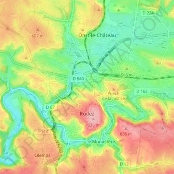
Name: Rodez topographic map, elevation, terrain.
Location: Rodez, Aveyron, Occitania, Metropolitan France, 12000, France (44.34053 2.53335 44.37763 2.60642)
Average elevation: 567 m
Minimum elevation: 502 m
Maximum elevation: 646 m
The city has had a longstanding public transport system, the tramway of Rodez having circulated from 1902 to 1920. Nowadays, these journeys are made by buses. Agglobus is the transit network serving the communes of the Communauté d'agglomération du Grand Rodez , nearly 60,000 people, where a multiple purchase ticket shall not exceed €0.20. It allows service to the centre of Rodez from outside communes (and vice versa) before 8am with a time range for operation of the service between 7am (5am for some lines) and 8pm. These lines have scheduled timing. This network is complemented by an evening service that operates Monday to Saturday, from 8pm to 11:30pm, by a transport service scheduled running Monday to Saturday with two round trips per day, and for persons with reduced mobility which works at the same times as the bus network. The Rodez topography makes it difficult to create special lanes for buses. As such, the Agglobus network is equipped with a system of prioritisation at traffic lights and also a geolocation for buses.
Other topographic maps
Click on a map to view its topography, its elevation and its terrain.
Le Dourdou de Conques
Le Dourdou de Conques, Aveyron, Occitania, Metropolitan France, France
Average elevation: 576 m
Puech de Montabez
France > Occitania > Aveyron > Florentin-la-Capelle
Puech de Montabez, Florentin-la-Capelle, Rodez, Aveyron, Occitania, Metropolitan France, 12140, France
Average elevation: 662 m
La Malette
France > Occitania > Aveyron > Entraygues-sur-Truyère
La Malette, Entraygues-sur-Truyère, Rodez, Aveyron, Occitania, Metropolitan France, 12140, France
Average elevation: 410 m
Novis
France > Occitania > Aveyron > Sévérac d'Aveyron > Sévérac-le-Château
Novis, Sévérac-le-Château, Sévérac d'Aveyron, Rodez, Aveyron, Occitania, Metropolitan France, 12150, France
Average elevation: 848 m
Saint-Izaire
Saint-Izaire, Millau, Aveyron, Occitania, Metropolitan France, 12480, France
Average elevation: 383 m
La Graufesenque
France > Occitania > Aveyron > Millau > La Graufesenque
La Graufesenque, Millau, Aveyron, Occitania, Metropolitan France, 12100, France
Average elevation: 529 m
Palmas
France > Occitania > Aveyron > Palmas d'Aveyron
Palmas, Palmas d'Aveyron, Rodez, Aveyron, Occitania, Metropolitan France, 12310, France
Average elevation: 613 m
Entraygues-sur-Truyère
Entraygues-sur-Truyère, Rodez, Aveyron, Occitania, Metropolitan France, 12140, France
Average elevation: 482 m
Salles-la-Source
Salles-la-Source, Rodez, Aveyron, Occitania, Metropolitan France, 12330, France
Average elevation: 519 m
La Rouquette
La Rouquette, Villefranche-de-Rouergue, Aveyron, Occitania, Metropolitan France, 12200, France
Average elevation: 340 m
Rieupeyroux
Rieupeyroux, Villefranche-de-Rouergue, Aveyron, Occitania, Metropolitan France, 12240, France
Average elevation: 613 m