
Annapolis topographic map
Interactive map
Click on the map to display elevation.
About this map
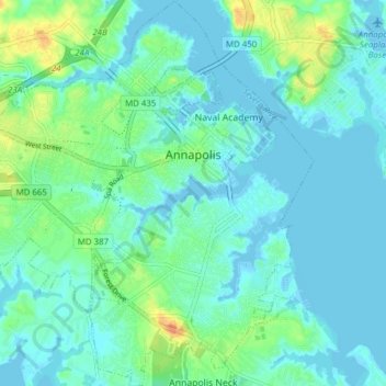
Name: Annapolis topographic map, elevation, terrain.
Location: Annapolis, Anne Arundel County, Maryland, United States (38.94250 -76.53958 39.00255 -76.46868)
Average elevation: 8 m
Minimum elevation: -5 m
Maximum elevation: 34 m
Annapolis lies within the humid subtropical climate zone (Köppen Cfa), with hot, humid summers, cool winters, and generous precipitation year-round. Low elevation and proximity to the Chesapeake Bay give the area more moderate spring and summertime temperatures and slightly less extreme winter lows than locations further inland, such as Washington, D.C.
Other topographic maps
Click on a map to view its topography, its elevation and its terrain.
High Point
United States > Maryland > Anne Arundel County > Pasadena
High Point, Pasadena, Anne Arundel County, Maryland, 21122, United States
Average elevation: 12 m
Springwood
United States > Maryland > Anne Arundel County > Jessup
Springwood, Jessup, Anne Arundel County, Maryland, 20794, United States
Average elevation: 63 m
Benfield
United States > Maryland > Anne Arundel County > Glen Burnie
Benfield, Glen Burnie, Anne Arundel County, Maryland, 21108, United States
Average elevation: 25 m
Highland Beach
United States > Maryland > Anne Arundel County
Highland Beach, Anne Arundel County, Maryland, United States
Average elevation: 3 m
Leeds
United States > Maryland > Anne Arundel County
Leeds, Anne Arundel County, Maryland, 21077, United States
Average elevation: 47 m
Boones Mobile Estates
United States > Maryland > Anne Arundel County
Boones Mobile Estates, Anne Arundel County, Maryland, 20711, United States
Average elevation: 30 m
Crofton
United States > Maryland > Anne Arundel County
Crofton, Anne Arundel County, Maryland, 21114, United States
Average elevation: 35 m
Franklin Manor Beach
United States > Maryland > Anne Arundel County
Franklin Manor Beach, Anne Arundel County, Maryland, 20733, United States
Average elevation: 1 m
Woodcrest
United States > Maryland > Anne Arundel County > Ferndale
Woodcrest, Ferndale, Anne Arundel County, Maryland, 21062, United States
Average elevation: 28 m
Riva
United States > Maryland > Anne Arundel County
Riva, Anne Arundel County, Maryland, 21041, United States
Average elevation: 11 m
Pasadena Beach
United States > Maryland > Anne Arundel County
Pasadena Beach, Anne Arundel County, Maryland, United States
Average elevation: 4 m
Crownsville
United States > Maryland > Anne Arundel County > Crownsville
Crownsville, Anne Arundel County, Maryland, 21140, United States
Average elevation: 30 m
Green Haven
United States > Maryland > Anne Arundel County > Pasadena
Green Haven, Pasadena, Anne Arundel County, Maryland, 21122, United States
Average elevation: 15 m
Deale
United States > Maryland > Anne Arundel County > Deale
Deale, Anne Arundel County, Maryland, United States
Average elevation: 5 m
Galesville
United States > Maryland > Anne Arundel County > Galesville
Galesville, Anne Arundel County, Maryland, United States
Average elevation: 4 m
Powhatan Village
United States > Maryland > Anne Arundel County > Pasadena
Powhatan Village, Pasadena, Anne Arundel County, Maryland, 21060, United States
Average elevation: 19 m
Lower Magothy Beach
United States > Maryland > Anne Arundel County > Severna Park
Lower Magothy Beach, Severna Park, Anne Arundel County, Maryland, 21122, United States
Average elevation: 9 m
Cranberry Woods
United States > Maryland > Anne Arundel County > Crownsville
Cranberry Woods, Crownsville, Anne Arundel County, Maryland, 21140, United States
Average elevation: 32 m
Edgewater Beach
United States > Maryland > Anne Arundel County > Riva
Edgewater Beach, Riva, Anne Arundel County, Maryland, 21041, United States
Average elevation: 9 m
Fort Meade
United States > Maryland > Anne Arundel County > Fort Meade
Fort Meade, Anne Arundel County, Maryland, 20755, United States
Average elevation: 53 m
Churchton
United States > Maryland > Anne Arundel County
Churchton, Anne Arundel County, Maryland, 20733, United States
Average elevation: 2 m
Edgewater
United States > Maryland > Anne Arundel County
Edgewater, Anne Arundel County, Maryland, 21037, United States
Average elevation: 7 m
Jacobsville
United States > Maryland > Anne Arundel County > Pasadena
Jacobsville, Pasadena, Anne Arundel County, Maryland, 21122, United States
Average elevation: 18 m
Avalon Shores
United States > Maryland > Anne Arundel County > Shady Side
Avalon Shores, Shady Side, Anne Arundel County, Maryland, 20764, United States
Average elevation: 1 m
Odenton
United States > Maryland > Anne Arundel County > Odenton
Odenton, Anne Arundel County, Maryland, United States
Average elevation: 41 m
Gambrills
United States > Maryland > Anne Arundel County > Gambrills
Gambrills, Anne Arundel County, Maryland, United States
Average elevation: 37 m
Venice Beach
United States > Maryland > Anne Arundel County > Arundel on the Bay > Venice Beach
Venice Beach, Highland Beach, Arundel on the Bay, Anne Arundel County, Maryland, 21403, United States
Average elevation: 2 m
Annapolis
United States > Maryland > Anne Arundel County > Annapolis
Annapolis, Anne Arundel County, Maryland, 21411, United States
Average elevation: 13 m
Londontown Terrace
United States > Maryland > Anne Arundel County > Londontown Terrace
Londontown Terrace, Anne Arundel County, Maryland, 21037, United States
Average elevation: 4 m
Crofton
United States > Maryland > Anne Arundel County > Crofton
Crofton, Anne Arundel County, Maryland, 21114, United States
Average elevation: 35 m
The Provinces
United States > Maryland > Anne Arundel County > Severn
The Provinces, Severn, Anne Arundel County, Maryland, 21144, United States
Average elevation: 57 m