
Bisingen topographic map
Interactive map
Click on the map to display elevation.
About this map
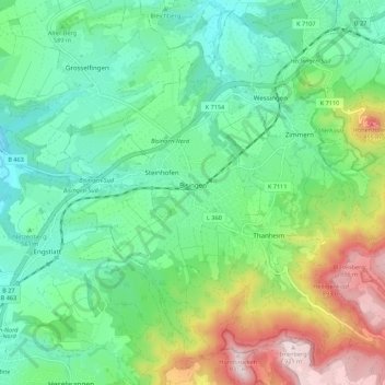
Name: Bisingen topographic map, elevation, terrain.
Average elevation: 609 m
Minimum elevation: 479 m
Maximum elevation: 927 m
Bisingen is physically located along the northern edge of the Swabian Jura, between the Hundsrücken and the Hohenzollern mountains. Elevation above sea level in the municipal area ranges from a low of 485 meters (1,591 ft) Normalnull (NN) on the Klingenbach to a high of 912 meters (2,992 ft) NN at the top of the Zeller Horn.