
Greater Accra Region topographic map
Interactive map
Click on the map to display elevation.
About this map
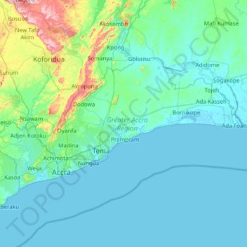
Name: Greater Accra Region topographic map, elevation, terrain.
Location: Greater Accra Region, Ghana (5.47065 -0.51970 6.10761 0.67226)
Average elevation: 62 m
Minimum elevation: -5 m
Maximum elevation: 665 m
Other topographic maps
Click on a map to view its topography, its elevation and its terrain.
Kumasi
Ghana > Ashanti Region > Kumasi Metropolitan District
Kumasi, Kumasi Metropolitan District, Ashanti Region, Ghana
Average elevation: 256 m
Boankra
Ghana > Ashanti Region > Ejisu Municipal District
Boankra, Ejisu Municipal District, Ashanti Region, Ghana
Average elevation: 234 m
Atua
Ghana > Western North Region > Aowin Municipal District > Enchi
Atua, Zongo, Enchi, Aowin Municipal District, Western North Region, Ghana
Average elevation: 88 m
Agate
Ghana > Volta Region > Afadzato South District
Agate, Afadzato South District, Volta Region, Ghana
Average elevation: 259 m
James Fort
Ghana > Greater Accra Region > Accra Metropolitan District > Accra
James Fort, Cleland Road, Bukom, James Town, Accra, Accra Metropolitan District, Greater Accra Region, GA-222-2148, Ghana
Average elevation: 6 m
Banue Nkwanta
Ghana > Bono Region > Sunyani Municipal District
Banue Nkwanta, Sunyani Municipal District, Bono Region, Ghana
Average elevation: 280 m
Tema
Ghana > Greater Accra Region > Tema Metropolitan District > Tema
Tema, Tema Metropolitan District, Greater Accra Region, GT-020-5892, Ghana
Average elevation: 22 m
Bolgatanga
Ghana > Bolgatanga Municipal District
Bolgatanga, Bolgatanga Municipal District, Upper East Region, Ghana
Average elevation: 193 m
Accra
Ghana > Greater Accra Region > Korle-Klottey Municipal District
Accra, Korle-Klottey Municipal District, Greater Accra Region, Ghana
Average elevation: 31 m
Have
Ghana > Volta Region > Afadzato South District > Have
Have, Afadzato South District, Volta Region, Ghana
Average elevation: 269 m
Rattray Park
Ghana > Ashanti Region > Kumasi
Rattray Park, Nhyiaeso, Kumasi, Ashanti Region, Ghana
Average elevation: 261 m
Kassena Nankana West District
Kassena Nankana West District, Upper East Region, Ghana
Average elevation: 233 m
Tamale
Ghana > Northern Region > Tamale
Tamale, Northern Region, P.O. BOX 232, Ghana
Average elevation: 151 m