
Uasin Gishu County topographic map
Interactive map
Click on the map to display elevation.
About this map
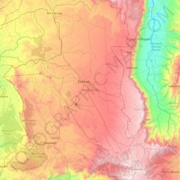
Name: Uasin Gishu County topographic map, elevation, terrain.
Location: Uasin Gishu County, Rift Valley, Kenya (0.00649 34.85349 0.94350 35.59131)
Average elevation: 1,933 m
Minimum elevation: 1,007 m
Maximum elevation: 2,886 m
Uasin Gishu County is one of the 47 counties of Kenya located in the former Rift Valley Province. Eldoret has the county's largest population center as well as its administrative and commercial center.[1] “It lies between longitudes 34 degrees 50’ east and 35 degrees 37’ West and latitudes 0 degrees 03’ South and 0 degrees 55’ North. It is a highland plateau with altitudes falling gently from 2,700 meters above sea level to about 1,500 meters above sea level. The topography is higher to the east and declines gently towards the western border”.[2]
Other topographic maps
Click on a map to view its topography, its elevation and its terrain.
Kesses
Kesses, Uasin Gishu County, Rift Valley, Kenya
Average elevation: 2,224 m
Gatanga
Gatanga, Murang'a County, Central Kenya, Kenya
Average elevation: 1,838 m
Kuresoi North
Kuresoi North, Nakuru West, Nakuru, Rift Valley, Kenya
Average elevation: 2,451 m
Chesumei
Chesumei, Nandi County, Rift Valley, 30306, Kenya
Average elevation: 1,966 m
Ainabkoi
Ainabkoi, Uasin Gishu County, Rift Valley, Kenya
Average elevation: 2,168 m
Mathioya
Mathioya, Murang'a County, Central Kenya, Kenya
Average elevation: 2,388 m
Kapseret
Kapseret, Uasin Gishu County, Rift Valley, Kenya
Average elevation: 2,092 m
Kigumo
Kigumo, Murang'a County, Central Kenya, Kenya
Average elevation: 1,959 m
Kangema
Kangema, Murang'a County, Central Kenya, 10202, Kenya
Average elevation: 1,828 m
Maragua
Kenya > Murang'a County > Murang`a South
Maragua, Murang`a South, Murang'a County, Central Kenya, Kenya
Average elevation: 1,355 m
Imenti North
Imenti North, Meru County, Eastern, 60200, Kenya
Average elevation: 1,532 m
Mwea
Kenya > Kirinyaga County > Mwea East
Mwea, Mwea East, Kirinyaga County, Central Kenya, Kenya
Average elevation: 1,194 m
Igembe Central
Igembe Central, Meru County, Eastern, 60600, Kenya
Average elevation: 827 m
Kirinyaga Central
Kirinyaga Central, Kirinyaga County, Central Kenya, 10300, Kenya
Average elevation: 2,081 m
Mathira
Kenya > Laikipia County > Laikipia West
Mathira, Laikipia West, Laikipia County, Rift Valley, Kenya
Average elevation: 1,799 m
Imenti Central
Imenti Central, Meru County, Eastern, Kenya
Average elevation: 1,318 m
Imenti South
Imenti South, Meru County, Eastern, 60402, Kenya
Average elevation: 1,756 m
Kiharu
Kiharu, Murang'a County, Central Kenya, 10200, Kenya
Average elevation: 1,370 m
Kenya
Kenya > Nakuru > Nakuru East > Nakuru East ward
Kenya, Nakuru East ward, Nakuru East, Nakuru, Rift Valley, Kenya
Average elevation: 1,831 m
Nandi Hills
Nandi Hills, Nandi County, Rift Valley, Kenya
Average elevation: 1,983 m
Moiben
Moiben, Uasin Gishu County, Rift Valley, 30100, Kenya
Average elevation: 2,000 m