
Hayesville topographic map
Interactive map
Click on the map to display elevation.
About this map
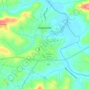
Name: Hayesville topographic map, elevation, terrain.
Location: Hayesville, Clay County, North Carolina, United States (35.02421 -83.82989 35.05616 -83.80778)
Average elevation: 573 m
Minimum elevation: 542 m
Maximum elevation: 660 m
Other topographic maps
Click on a map to view its topography, its elevation and its terrain.
Beach Mountain
United States > North Carolina > Clay County
Beach Mountain, Clay County, North Carolina, 28909, United States
Average elevation: 618 m