
Seinäjoki topographic map
Interactive map
Click on the map to display elevation.
About this map
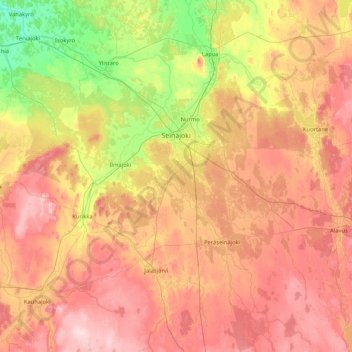
Name: Seinäjoki topographic map, elevation, terrain.
Average elevation: 91 m
Minimum elevation: 5 m
Maximum elevation: 194 m
Other topographic maps
Click on a map to view its topography, its elevation and its terrain.
Nurmo
Finland > South Ostrobothnia > Seinäjoki
Nurmo, Seinäjoki, Seinäjoki sub-region, South Ostrobothnia, Western and Central Finland, Mainland Finland, 60550, Finland
Average elevation: 51 m