
Tauranga City topographic map
Interactive map
Click on the map to display elevation.
About this map
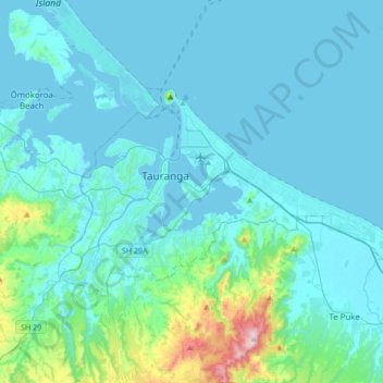
Name: Tauranga City topographic map, elevation, terrain.
Location: Tauranga City, Bay of Plenty, New Zealand (-37.77056 176.07411 -37.62409 176.41504)
Average elevation: 55 m
Minimum elevation: -1 m
Maximum elevation: 546 m
Other topographic maps
Click on a map to view its topography, its elevation and its terrain.
Rotorua District
Rotorua District, Bay of Plenty, New Zealand
Average elevation: 404 m
Gisborne Point
New Zealand > Bay of Plenty > Gisborne Point
Gisborne Point, Rotorua District, Bay of Plenty, 3074, New Zealand
Average elevation: 350 m
Mount Tarawera
New Zealand > Bay of Plenty > Rotorua
Mount Tarawera, Rotorua, Rotorua District, Bay of Plenty, New Zealand
Average elevation: 894 m
Rotorua
New Zealand > Bay of Plenty > Rotorua
Rotorua, Rotorua District, Bay of Plenty, 3010, New Zealand
Average elevation: 435 m