
Rudice topographic map
Interactive map
Click on the map to display elevation.
About this map
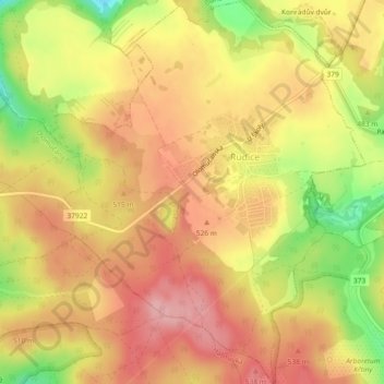
Name: Rudice topographic map, elevation, terrain.
Location: Rudice, okres Blansko, Jihomoravský kraj, Southeast, Czechia (49.31962 16.70225 49.34949 16.74008)
Average elevation: 501 m
Minimum elevation: 412 m
Maximum elevation: 556 m
Other topographic maps
Click on a map to view its topography, its elevation and its terrain.
Komořany
Czechia > Southeast > Jihomoravský kraj
Komořany, okres Vyškov, Jihomoravský kraj, Southeast, Czechia
Average elevation: 274 m
Moravian Karst
Czechia > Southeast > Habrůvka
Moravian Karst, Lesní cesta Padouch, Habrůvka, okres Blansko, Jihomoravský kraj, Southeast, 368, Czechia
Average elevation: 433 m
Jasenice
Czechia > Southeast > Kraj Vysočina
Jasenice, okres Třebíč, Kraj Vysočina, Southeast, Czechia
Average elevation: 468 m