
Plainfield topographic map
Interactive map
Click on the map to display elevation.
About this map
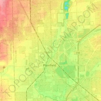
Name: Plainfield topographic map, elevation, terrain.
Location: Plainfield, Will County, Illinois, United States (41.56923 -88.31210 41.68019 -88.16318)
Average elevation: 194 m
Minimum elevation: 149 m
Maximum elevation: 236 m
Like its namesake, Plainfield's topography is generally flat. Thousands of years ago, land in greater Plainfield used to be part of the bed of proglacial Lake Wauponsee. However, the lake did not hold up long, and eventually drained into the Illinois River valley.[13] The lake left behind a very flat landscape. Much of downtown Plainfield has an elevation of around 600–625 feet (183–191 m) above sea level, with some areas in the western and northwestern portions of the village's outskirts exceeding 700 feet (210 m). This rise in elevation was created by terminal moraines that were formed during the Wisconsin Episode of the last ice age's last glacial period that has been recorded.
Other topographic maps
Click on a map to view its topography, its elevation and its terrain.
New Lenox
United States > Illinois > Will County
New Lenox, Will County, Illinois, 60451, United States
Average elevation: 209 m
Welco Corners
United States > Illinois > Will County > Bolingbrook
Welco Corners, Bolingbrook, Will County, Illinois, 60440, United States
Average elevation: 219 m
Frankfort
United States > Illinois > Will County > Frankfort
Frankfort, Will County, Illinois, United States
Average elevation: 225 m
Wilmington
United States > Illinois > Will County > Wilmington
Wilmington, Will County, Illinois, 60481, United States
Average elevation: 175 m
Joliet
United States > Illinois > Will County
Joliet, Will County, Illinois, United States
Average elevation: 195 m