
Gatineau topographic map
Interactive map
Click on the map to display elevation.
About this map
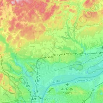
Name: Gatineau topographic map, elevation, terrain.
Location: Gatineau, Outaouais, Quebec, Canada (45.45174 -75.76877 45.57731 -75.52618)
Average elevation: 107 m
Minimum elevation: 28 m
Maximum elevation: 284 m
Other topographic maps
Click on a map to view its topography, its elevation and its terrain.
Buckingham
Buckingham, Gatineau, Outaouais, Quebec, Canada
Average elevation: 124 m
Parc La Vérendrye
Parc La Vérendrye, 730, Gatineau, Gatineau (ville), Outaouais, Quebec, J8R 1S4, Canada
Average elevation: 89 m