
Laguna Niguel topographic map
Interactive map
Click on the map to display elevation.
About this map
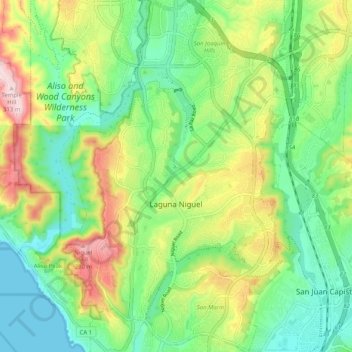
Name: Laguna Niguel topographic map, elevation, terrain.
Average elevation: 110 m
Minimum elevation: 0 m
Maximum elevation: 308 m
Laguna Niguel consists of mostly hilly terrain, being located within the San Joaquin Hills. The average elevation is 400 feet (120 m); elevations range from near sea level to 936 feet (285 m) at the summit of Niguel Hill, in the southwest corner of the city. Neighboring cities are Aliso Viejo and Laguna Hills to the north, Mission Viejo and San Juan Capistrano to the east, and Laguna Beach and Dana Point to the south. On the west, it borders the significant unincorporated acreage of Aliso and Wood Canyons Wilderness Park.