
Saint-Avertin topographic map
Interactive map
Click on the map to display elevation.
About this map
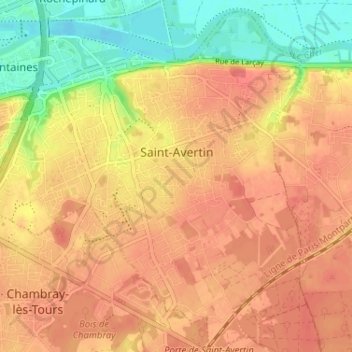
Name: Saint-Avertin topographic map, elevation, terrain.
Average elevation: 81 m
Minimum elevation: 43 m
Maximum elevation: 103 m
Other topographic maps
Click on a map to view its topography, its elevation and its terrain.
Richelieu
France > Centre-Val de Loire > Indre-et-Loire
Richelieu, Chinon, Indre-et-Loire, Centre-Val de Loire, Metropolitan France, 37120, France
Average elevation: 59 m
Saint-Roch
France > Centre-Val de Loire > Indre-et-Loire
Saint-Roch, Chinon, Indre-et-Loire, Centre-Val de Loire, Metropolitan France, 37390, France
Average elevation: 95 m