
Antrim topographic map
Interactive map
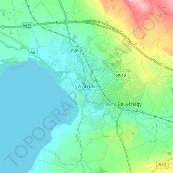
Click on the map to display elevation.
About this map
Name: Antrim topographic map, elevation, terrain.
Average elevation: 50 m
Minimum elevation: 9 m
Maximum elevation: 204 m
Other topographic maps
Click on a map to view its topography, its elevation and its terrain.
Belfast
United Kingdom > Northern Ireland > County Antrim
Belfast, County Antrim, Northern Ireland, United Kingdom
Average elevation: 92 m
Larne
United Kingdom > Northern Ireland > County Antrim > Larne
Larne, County Antrim, Northern Ireland, BT40 1JS, United Kingdom
Average elevation: 54 m
Belfast
United Kingdom > Northern Ireland > County Antrim
Belfast, County Antrim, Ulster, Northern Ireland, BT1 5GS, United Kingdom
Average elevation: 87 m