
Paris topographic map
Interactive map
Click on the map to display elevation.
About this map
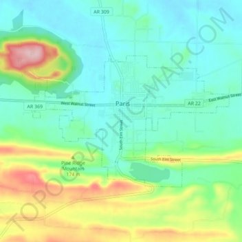
Name: Paris topographic map, elevation, terrain.
Location: Paris, Logan County, Arkansas, 72855, United States (35.26815 -93.76197 35.30659 -93.67552)
Average elevation: 165 m
Minimum elevation: 107 m
Maximum elevation: 311 m
Other topographic maps
Click on a map to view its topography, its elevation and its terrain.
Booneville
United States > Arkansas > Logan County
Booneville, Logan County, Arkansas, 72927, United States
Average elevation: 153 m
Saint Scholastica
United States > Arkansas > Logan County
Saint Scholastica, Logan County, Arkansas, 72851, United States
Average elevation: 142 m
Driggs
United States > Arkansas > Logan County
Driggs, Logan County, Arkansas, United States
Average elevation: 227 m
Mount Magazine State Park
United States > Arkansas > Logan County
Mount Magazine State Park, Signal Hill Trail, Logan County, Arkansas, United States
Average elevation: 667 m