
Luling topographic map
Interactive map
Click on the map to display elevation.
About this map
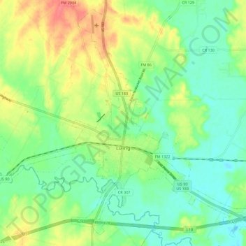
Name: Luling topographic map, elevation, terrain.
Location: Luling, Caldwell County, Texas, 78468, United States (29.64527 -97.70030 29.73462 -97.58941)
Average elevation: 121 m
Minimum elevation: 99 m
Maximum elevation: 156 m
Other topographic maps
Click on a map to view its topography, its elevation and its terrain.
Dale
United States > Texas > Caldwell County
Dale, Caldwell County, Texas, 78616, United States
Average elevation: 155 m
Uhland
United States > Texas > Caldwell County
Uhland, Caldwell County, Texas, United States
Average elevation: 180 m
Lockhart
United States > Texas > Caldwell County
Lockhart, Caldwell County, Texas, 78644, United States
Average elevation: 156 m
Fentress
United States > Texas > Caldwell County > Fentress
Fentress, Caldwell County, Texas, 78922, United States
Average elevation: 139 m
Lockhart
United States > Texas > Caldwell County > Lockhart > Lockhart
Lockhart, Caldwell County, Texas, 78644, United States
Average elevation: 157 m