
Ranong Province topographic map
Interactive map
Click on the map to display elevation.
About this map
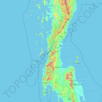
Name: Ranong Province topographic map, elevation, terrain.
Location: Ranong Province, Thailand (7.48695 96.12701 12.60695 101.24701)
Average elevation: 31 m
Minimum elevation: -3 m
Maximum elevation: 1,417 m
Other topographic maps
Click on a map to view its topography, its elevation and its terrain.
Ranong
Ranong, Pak Nam Tha Ruea, Ranong Province, Thailand
Average elevation: 103 m