
Prudnik County topographic map
Interactive map
Click on the map to display elevation.
About this map
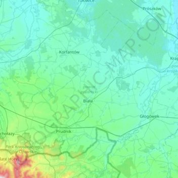
Name: Prudnik County topographic map, elevation, terrain.
Location: Prudnik County, Opole Voivodeship, Poland (50.26500 17.44740 50.55460 18.03235)
Average elevation: 236 m
Minimum elevation: 153 m
Maximum elevation: 944 m
Other topographic maps
Click on a map to view its topography, its elevation and its terrain.
Lubsza
Poland > Opole Voivodeship > Brzeg County
Lubsza, gmina Lubsza, Brzeg County, Opole Voivodeship, 49-313, Poland
Average elevation: 137 m
Opole County
Poland > Opole Voivodeship > Opole County
Opole County, Opole Voivodeship, Poland
Average elevation: 192 m
Kędzierzyn-Koźle
Poland > Opole Voivodeship > Kędzierzyn-Koźle County
Kędzierzyn-Koźle, Kędzierzyn-Koźle County, Opole Voivodeship, Poland
Average elevation: 191 m
Kluczbork
Poland > Opole Voivodeship > Kluczbork County > Kluczbork
Kluczbork, gmina Kluczbork, Kluczbork County, Opole Voivodeship, Poland
Average elevation: 185 m
Olesno County
Olesno County, Opole Voivodeship, Poland
Average elevation: 224 m
Nysa
Poland > Opole Voivodeship > Nysa County > Nysa
Nysa, gmina Nysa, Nysa County, Opole Voivodeship, Poland
Average elevation: 202 m
Jastrzębie
Poland > Opole Voivodeship > Jastrzębie
Jastrzębie, gmina Namysłów, powiat namysłowski, Opole Voivodeship, Poland
Average elevation: 166 m
Kędzierzyn-Koźle
Poland > Opole Voivodeship > Kędzierzyn-Koźle
Kędzierzyn-Koźle, powiat kędzierzyńsko-kozielski, Opole Voivodeship, Poland
Average elevation: 191 m
Praszka
Poland > Opole Voivodeship > Praszka > Praszka
Praszka, gmina Praszka, Olesno County, Opole Voivodeship, Poland
Average elevation: 197 m
Prudnik
Poland > Opole Voivodeship > Prudnik > Prudnik
Prudnik, gmina Prudnik, Prudnik County, Opole Voivodeship, 48-200, Poland
Average elevation: 282 m
Olesno
Poland > Opole Voivodeship > Olesno
Olesno, gmina Olesno, powiat oleski, Opole Voivodeship, 46-300, Poland
Average elevation: 246 m