
Ehrenberg topographic map
Interactive map
Click on the map to display elevation.
About this map
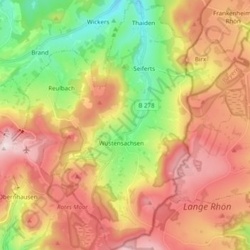
Name: Ehrenberg topographic map, elevation, terrain.
Location: Ehrenberg, Landkreis Fulda, Hesse, Germany (50.46118 9.94088 50.55038 10.04258)
Average elevation: 708 m
Minimum elevation: 461 m
Maximum elevation: 953 m
Other topographic maps
Click on a map to view its topography, its elevation and its terrain.
Fulda
Germany > Hesse > Landkreis Fulda
Fulda, Landkreis Fulda, Hesse, Germany
Average elevation: 324 m